
Desert in Peru with mysterious gigantic drawings. Lines and geoglyphs of Naska and palp

Considering the huge drawings on the surface of the earth, the pictures of which are made from the air, the question arises, could this make people? The most mysterious place on the planet is considered to be the Plateau of Nask, which surprised scientists even 100 years ago with their mysterious drawings. To date, scientists have shown various theories of the appearance of these drawings, but none of them gave an accurate answer about the origin of these masterpieces.
Let's follow the studies of scientists and try to find some explanations to these drawings.
Plateau Nask or Pampa, as it is called, is located at a distance of 450 km from the capital of Peru _ Lima. Its length is 60 km, and 500 square meters. Meters are covered with various mysterious lines, which make up mysterious drawings. Pictures present in this area are images of geometric shapes, animals, insects and amazing appearance people. Drawings can be seen only from the air, as it is huge images.
When examining the area it was found that the drawings are dug in the sandy ground to a depth of 10-30 cm, and the width of some lines can be up to 100 meters (!). Pictures lines may have a length of several kilometers, while literally without changing from the effect of the form of terrain. The lines rise and descend from the hills, but their continuity and perfect evenness is not broken. Immediately the question arises, who is the creator of such a picture in the wilderness - unknown people or aliens from a distant cosmos? But on this question, scientists have not yet managed to find an answer.
To date, scientists with accuracy managed to establish the age of this "painting". Scientists carefully investigated the remains of plant and organic origin found in the places of drawings, found that the drawings were created in the time of time, starting from 350 BC. 600 BC BC.
But this fact is not exact evidence of the date of the appearance of drawings, since these items could get here later than creating drawings. There is also another scientific theory, which says that the drawings are the work of the Naska Indians, who could inhabit this area of \u200b\u200bPeru (even before the arrival of the Incas). After the disappearance of this people on Earth, there was not a single historical mention of them, except for burials. And therefore scientists cannot accurately assert the involvement of this nation to drawings.

Let's look into historical sources in which the drawings of Nask are mentioned. For the first time they mentioned Spanish researchers in their manuscripts, which are dated XV - XVII centuries. Nowadays, these information sources attracted the attention of modern scientists, but the most interesting discoveries have become available when creating first aircraft, as the drawings lines are folded into a single whole and open their mystery only from a bird's eye view.
The first scientist, who opened the drawings of Nask, became the Peruvian archaeologist Mexerage Kates, who saw them part from the elephant of one of the mountains in 1927. At the same time to explore Naska steel in the 40s, then the first photographs of the drawings made from the aircraft appeared. These studies were led by the American historian Paul Kosovo. But in fact, on the eve of the first photos of the drawings of Naska, they were discovered by pilots who were engaged in finding water sources in the desert. I was looking for water, and found the most mysterious riddle of our planet.
Kosovo at one time put forward one of numerous theories, which assumed that the drawings are nothing more than a huge astronomical calendar. He brought similar drawings from the starry sky for clarity. It turned out that some lines show the direction of constellation and point to the sunrise point and sunset. The theory of Kosli was developed in the work of mathematician and astronoma Mary Rayhe, which devoted more than 40 years to systematization and study of the NASK drawings. She managed to find out that the drawings in the Naska desert were made manually.
Birds and animals were the first printed figures, and then various lines were conducted on top of these drawings. Also, the scientist managed to find sketch sketches, which were later embodied in full. Ancient "artists" used coordinate poles for more accurate orientation on the terrain and the preparation of accurate drawings. These landmarks were at some points of the figures. If the figures can be observed only with high height, it suggests that the people who applied them to the surface of the Earth could fly. Thus, a new theory appeared that the creators of NASK drawings were extraterrestrial civilization or created an airfield for aircraft.
Subsequently, it turned out that Naska is not the only place that has similar images. 10 km from the plateau (near the city of Palpa) there are similar drawings and lines, and at a distance of 1400 km at Mount Solitari is a huge statue of a person surrounded by lines and drawings similar to Nasca's drawings. On the territory of the Western Cordiller, two painted peelings of the spiral shape are located in the immediate vicinity of Naska, with different direction of turns. What is the most amazing that the space ray falls into the period of 1-5 times a year and illuminates this area for 20 minutes. There is even a statement of local residents, which if you get into this beam, you can cure from various diseases. Similar drawings were found in various countries of the world - Ohio (USA), England, in Africa, Altai and the Southern Urals. They are all different, but one unites them that they are not intended for earthly review.
Conducting excavations on the territory of Naska, scientists have found regular riddles for themselves. The shards found the drawings on which there were evidence that residents of this area knew about penguins. Scientists could not find another explanation to the found penguin figure on one of the shards. Also, archaeologists managed to find many loygads and tunnels. Some of these structures are an irrigation system, and the other part belongs to the underground city. The tips and ruins of underground temples are located here.

One of theories is the hypothesis of the origin of the NASK drawings associated with the activities of alien civilizations. For the first time, such a hypothesis put forward a Swiss writer Erich von Denicen. He argued that our planet in the Nasca area was visited by aliens, but he is not sure that the drawings are their hands. According to his theory, the drawings are designed to call aliens who left our planet. Triangles informed pilots-aliens about the presence of lateral wind, and rectangles about the landing place.
Straight lines in the form of recesses could fill with a combustible substance and be a signage to the direction of the landing strip. This theory is fantastic and seriously not perceived in the scientific world, but even a writer managed to sow doubts about the scientific theories of the origin of the NASK drawings. Then the theory of energy flows arose, which indicates the relationship of mankind with an alien mind. One example is the huge image of the "Parakas Kandelara" - the drawing on the mountainside on the Peruvian Parakas Peninsula.
Scientists believe the candelabr is an information source about our planet. In the left part of the picture is hidden information about the earth's fauna, and in the right part of the Flora. The general image is made in the form of a human face. Where there is a top of the drawing Ancient residents of Naska installed a pointer, which is a scale of civilization. For the same theory, there is an opinion that our civilization was created by aliens from the constellation of Leo. Perhaps the composition of straight lines was created by aliens to designate a runway for their ships.
There are other evidence of this theory. Scientists from England managed to explore the component of the muscle mass of the Mummy Inca. And the results turned out simply stunning. The blood of the Inca did not have analogues with the blood groups of the residents of the land of that historical period. This blood group is a very rare combination ...
But of course, the truth is born in the dispute. And therefore, they found those who discard all the alien theories. In the early 80s, a group of students, taking with them wooden shovels, created an "elephant", which is similar to the drawings of Nask. But their conviction did not greatly affected and in our time there are many supporters of alien participation in creating huge drawings.
Options for theories of the appearance of large drawings on Earth:
Animal drawings are created as the memory of the global flood.
Naska drawings are one of the ancient zodiac calendars.
Drawn figures are created for ritual ceremonies of water culture, and the line is the direction of aqueduct.
The trajectory of the drawings was used for sprint race (the truth is hard to believe it).
The lines and drawings of Naska are an encrypted message, a certain code. It has a number of pi, radian degrees (360 °), a decimal calculus system, etc.
The drawings are drawn with shamans under the action of strong hallucinogen (though, the theory is funny).
No matter how many theories of the emergence and purpose of NASK drawings were not put forward, but the mystery remains not disclosed. In addition, this mysterious plateau presents all new riddles to mankind. In this area, Peru constantly departs new researchers. This area is available for both scientists and tourists, but does a person get a curtain of mystery that closes the true purpose of the drawings from us?
Geoglyphs at Naska Plateau, like the famous Lost City of Inca-Picchu, is one of the most mysterious attractions of Peru. Giant geometric shapes depicting triangles, spirals, lines, constellations, as well as a monkey, spider, flowers, astronauts and hummingbirds, whose wings are exceeding two hundred meters, were created between I and V century AD. There is no consensus on the origin of the drawings deposited by deep furrows, and there are no goals of their creation so far, despite many years of research.
The Nasky lines were first seen in 1939 by the American archaeologist by Holly Kosovo, who performed a flight over the plateau. He saw that the lines fix the moon phases and point to some constellations. Detect such parallels from the ground was impossible; It is possible to distinguish the figures to this day only from the air. In the future, their research was engaged in Maria Riete, and many drawings were open with its help. According to Riekhe, geoglyphs in the desert are the largest stellar sky calendar in the world in the world. In total, the Nasc Plateau can detect about thirty drawings, 788 diverse geometric figures, including trapezoids, triangles and spirals, and thousands of lines and strips. In 1994, Geoglyphs were listed by UNESCO World Heritage Site.
For traveling on the Plateau Naska, choose lightweight lights and closed shoes with a rigid sole. The best time for inspecting geoglyphs in the desert - from December to March, when you can count on clear sunny weather. The temperature during this period does not fall below + 27 ° C. Even going into the way in the early morning or with the onset of twilight, do not forget about sunscreen and headdress.
In addition to geoglyphs, there are several other curious attractions at the Nasc Plateau. In particular, you can visit the ruins of Kauachi (Cahuachi) - the most important and powerful city of ancient civilization, where excavations still continue. 5 kilometers to the east of Nasks are the Aqueducts of Kantayok (Cantayoc), and in 30 kilometers to the south, the Necropolis of Chauchilla (El Cementerio de Chauchilla), most of whose burials are related to the V-VI centuries. Mummy were found in the first half of the last century, but the archaeological monument of necropolis was recognized only in 1997.
How to get
Plateau Nask is located 380 kilometers southeast of Lima. The path runs along the picturesque Pacific coast, along the 1S motorway. Getting from the capital to Nasca (Nazca) is most convenient with the transfer to ICA; Travel by bus on average takes seven and a half hours. Tickets must be taken in advance, minimum per day. Be careful: from Lima buses from different transport companies (Oltursa, Cruz Del Sur, TEPSA) are departed from different terminals; For example, flights TEPSA - from the terminal of the same name, located on Avenida Javier Prado Street. At the same time, not always the starting points are located in the city center. The cost of traveling to one end ranges from 65 Pen (~ $ 20.8) to 140 pen (~ $ 44.8) per person. Buses depart several times a day, including late in the evening and at night.
The best way to see Geoglyphs on the Naska Plateau is to go to one of the excursion tours on small Cessna aircraft that organize local agencies. In good weather, you can see the majority of drawings and lines; Guides make a route over the most famous areas of the desert, including those depicted by a monkey, spider, hummingbirds and other animals.
Routes start from Nask and Lima cities. Excursions should be booked in advance: the number of places in the aircraft is limited (as a rule, no more than five passengers), and organize such a journey in place is unlikely to succeed. Their cost from the city of Naska, for example, begins from $ 150 per person; The price includes a transfer from the hotel to the airfield, flight and facilities of the local guide. Such tours are held daily, mainly in the first half of the day, however, the departure time and duration of the journey depend on the number of flights scheduled on the day and weather conditions. On average, the excursion takes a little more than half an hour.
Organized excursions from Lima will cost more; Their cost begins from 350 dollars per person. This price includes a shuttle to the Nasky airfield, view a small film about the lines in the desert, flight, as well as lunch in the traditional restaurant and visiting the observation deck on the way back.
Helicopter excursions above Plateau Nask are organized by several specialized travel companies. The cost of such a journey begins from $ 350 per person; Flights are carried out daily. The duration of the excursion is 40 minutes, including the flight time - 25 minutes. The minimum number of passengers is two people.
Another option of the inspection of the Lines of the Network is an observation deck on the Pan American Highway (El Mirador). The cost of visits is 2 Pen (~ $ 0.6) per person. In this case, due to the great remoteness of the drawings, it will be possible to see only two of them.
Location
Plateau Nask is located in the province of the province of the ICA region, lying in almost the center of the Pacific coast.
Naska desert is located in the Department of ICA in the south of the country of Peru, between the Rivers of Inhenio and Naska. This territory is 500 square kilometers covered with huge images of people and animals, lines, spirals and geometric shapes, the size of which reaches up to 300m in length. These signs are so huge that you can only see them from the plane. However, everyone who wants today can admire the mysterious symbols without leaving the house, it is enough to run on the computer any program demonstrating satellite images of the Earth. Coordinates of the desert - 14 ° 41 "18.31" S 75 ° 07 "23.01" w.
The mystery of Naska desert was discovered in 1927, when the Peruvian pilot, flying over the desert valley in South Peru, saw that the Earth was drawn by long lines and painted with animal images. Such geometrical drawings appeared on the Naska plateau even during the Naska civilization. It is believed to dokolumbovy civilizations, II-IV century BC.
Geoglyphs are a big riddle, because it is not known to anyone why representatives of the disappeared ancient civilization of the Indians drew huge paintings, distinguishable only from the air. The images are imprisoned on the scanty rocky soil of the desert. At first glance, they are little distinguishable and are chaotic plexus of lines spent on someone on the reddish surface of the desert, but from the height of bird flight this chaoticism acquires meaning.

Despite the fact that geoglyphs were opened in the last century, the appointment of these amazing drawings is still unknown. Researchers A. Krebs and T. Mexium consider them part of an ancient irrigation system. T. Mexium also later also later suggested that the images are connected with the holy trop of the Inca. Some signs, for example, chilms from stones at the intersections of lines, indicate that the figures were used in rules.
P. Kozzov, who visited Naska Valley in 1941, drew attention to the special role of lines in the rays of the setting sun during the summer solstice and called these lines the largest textbook of astronomy. In the future, this theory in its studies was developed by the German researcher M. Riete. In her opinion, some of the geometric shapes symbolize constellations, and animal images - the location of the planets.

The study of astronomy for ancient civilizations was a great meaning. Among other things, it also had a practical function - helped to predict rain periods important for agriculture, but the archaeologist H. Lanko expressed a consideration that the drawings are cards indicating the path to vital places, for example, to underground water sources.
The most incredible and at the same time the most popular theory belongs to the famous Swiss researcher Erich von Danikin. He suggested that the images are nothing but a markup on the earth's surface for aliens from other planets.

No less surprising and other hypothesis, according to which representatives of the ancient civilization of Naska mastered the airplane, which is why the drawings are distinguishable only from the height. In confirmation of this theory, several dark spots, which are available on the surface of the plateau, are interpreted as footprints on the playgrounds for balloons. In addition, the Pottery products of the Indians of the Nari have patterns that resemble balloons or snakes.
The accurate age of geoglyphs is unknown. According to the results of archaeological studies, the images were created in different periods. The very first, the most straight lines arose, probably in the sixth century BC, the latest - animal drawings - in the first century of our era.

Scientists have proven that the figures were created manually. The drawings were applied to the surface of the desert in the form of a groove in 130 cm wide and 50 cm deep. On dark soil line form white stripes. Since light lines are heated less than the surrounding surface, the difference in pressure and temperatures arises, which leads to the fact that the lines do not suffer during sand storms.
Who and why painted in antiquity on the surface these pictures, distinguishable only from a high height, still remains a mystery. A huge number of theories were put forward, but none of the time has received scientific confirmation.
Do you know what Naska is? This is an ancient Indian civilization. It received its name from the river, in the valley of which to date you can admire the numerous monuments of culture. The flourishing of this civilization was observed in the first millennium to our era. Later, Nask's name was a small Indian village in the south of Peru, located behind the mountain ranges. In order to get to her from the capital of the state of Lima, it was necessary to drive a lot of kilometers along the dusty located in the rocky and sandy empty.
Today and the city of Naska connects a four-row motorway. Moreover, it is part of it, which passes through the bare hills and the desert, paved with wild stones. Little and quiet in the past village today is a small, but very accurate town. There is a private museum and a small park, various shops and even two banks. There are in the town of hotels in various classes that take tourists who went to this terrain in order to familiarize themselves with the world's famous "Pampo de Naska".
Geography
What attracts tourists from around the world a small town in the south of Peru? Travelers go here in order to look at the amazing and mysterious plateau of Nask. This is a plain located on some elevation. For her, as for all the plateau is characteristic, even, and sometimes a wavy relief. In places it happens slightly dismembered. From other plains, the plateau separate distinct ledges.
Where is Naska? Located this plateau in the south of Peru. From the capital of the country of Lima, it is separated by 450 km, which must be overcome in the southeastern direction. The map is located almost in the coastal zone of the Pacific. From the plateau to its endless water - no more than eighty kilometers.
The coordinates of Naska will help to find this locality on the map. They make up 14 ° 41 '18 "southern latitude and 75 ° 7' 22" Western longitude.
Plateau Naska has an extended form from the north to the south. Its length is 50 km. But the width of the terrain from Western to Eastern borders ranges from five to seven kilometers.
Natural conditions
The coordinates of Nasca are such that the area is located in the dry climate area. In this regard, she is Malonaselen. Winter here lasts from June to September. For us, it is surprising, but in the southern hemisphere it does not coincide with the one that is characteristic of the zone located north of the equator.
As for the air temperature, it is practically stable in this area. In the winter months, its value is not below sixteen degrees. In the summer, the thermometer column almost constantly keeps at +25.
Plateau Nask, as mentioned above, is in close proximity to the waters of the Pacific Ocean. However, despite this, rains here are a big rarity. None on the plateau and wind, since it is protected by mountain ranges from the air masses. There is also no rivers and streams in this desert. You can see here only their dried beds.
Lines of Nask.
However, numerous tourists in this edge attracts not its location. Plateau Nask manits mysterious drawings and lines located right on the earth's surface. Scientists call them geoglyphs. This concept means a geometric shape performed in the earth's ground, which is at least four meters long.
The Geoglyphs of Nask are grooves from a mixture of sand and pebbles, processed in the soil. They are not deep (15-30 cm), but long (up to 10 km) having a different width (from 150 to 200 m). Geoglyphs, or, as they are also called, the NASK lines are made in very bizarre. Here you can see the outlines of birds, spiders and animals, as well as geometric shapes. In total lines on the plateau about 13 thousand.

What is it? Secrets of stories? Riddles of the past? There is no unambiguous answer to these questions. Some scientists believe that the drawings of Naska are applied to the earth's surface by skillful human hands. However, it is not possible to confirm such an assumption. There is another, quite a steady opinion, according to which, stripes and lines were not applied by people, but by representatives of the alien reason. This is the greatest secret of the desert Nask, over which dozens of scientists are fighting. However, despite this, the puzzle of the Peruvian Plateau remains underestimated for the modern world.
History opening
The desert of Naska (Peru) is known for huge paintings located on the plateau. These drawings, created by unknown creators, belong to the greatest achievements of world culture and are an undoubted monument to the art of our entire planet.
For the first time, terrestrial gigantic paintings noticed pilots in 1927. But the scientific community of the Geoglyph of Naska became known only twenty years later. It was then that the American historian Paul Kosovo published a whole series of photographs of amazing and mysterious drawings, which were made from the air.
Technology of creation
Pictures of Naska are designed when removing debris, brown stones and volcanic pebbles, covered with a thin blackfold of black, with a bright subsoil consisting of a mixture of calcite, clay and sand. That is why the contours of gigantic figures are clearly visible from the board of the helicopter or aircraft.

From the air all lines on the background of the soil look more brighter, although from the ground or with low mountains such drawings merge from the ground, and it is impossible to distinguish them.
Lines and geometric shapes
All images that can be observed in the Naska desert have a different form. Some of them are stripes or lines whose width is located from fifteen centimeters to ten or more meters. Such soil deposits are quite long. They can reach from one to three and even more kilometers. Strips can also smoothly expand at their length.
Some Lines of Nask are elongated or truncated triangles. This is the most common view of the plateau. And the sizes are the most diverse and are in the range of one to three kilometers. Such triangles are often called trapezoids. Some drawings of Nask are large platforms that have a rectangular or incorrect form.
You can see such familiar to us from the geometry of quadrangles as a trapezoid (with two parallel sides) on the plateau. These creations with clear forms in the desert are the order of seven.
Many lines and platforms have some dug-shaped profile to thirty or more centimeters. Moreover, all these grooves have clear boundaries resembling a border.
Feature of lines Nask
The geoglyphs of the Peruvian desert were widely known due to their rectineality. The imagination of travelers literally affects the lines stretching on a lot of kilometers on the plateau, without difficulty overcoming all the features of the relief. In addition, the figures of Naska have peculiar centers, located, as a rule, on elevations. At these points, various types of lines are converging. Often, the deepening in the ground is connected to each other, uniting in the various combinations. It happens that the shapes and lines cover each other.
Interesting is the location of the trapezoids. Their bases are usually rotated on the side of the river valleys and are located below the narrow part.
Surprisingly what:
- the edges of all lines have the highest accuracy, the scatter of which is within only five centimeters for a length of several kilometers;
- the visibility of contours is preserved even when attaching figures on each other;
- there is a strict limitation of figures in width with significant strip lengths;
- the visibility of the strips is preserved even with changes in the characteristics of the soil;
- there is a similarity of the configuration and the location of the radiating figures with optical schemes;
- the geometry of figures is maintained even with complex relief;
- there are lines wearing an astronomical character pointing to the sides of the light or the days of equinox.
Diverse drawings
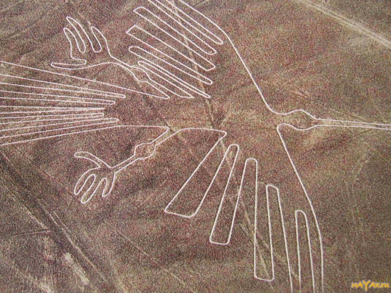
A peculiar decoration of large-scale platforms of Nask are zigzags and tight-shaped figures. Among the 13,000 lines, 800 sites and hundreds of various spirals in the amazing and mysterious Peruvian desert you can see the semantic drawings. These are three dozen figures of animals and birds, including:
- lizard 200 meters long crossed by the ribbon of the American highway, the builders of which did not notice the drawing;
- bird with a snake neck stretching 300 m;
- stater Condor;
- eighty meter spider.
In addition to these images, you can see fish and birds, a monkey and flower, something similar to a tree, as well as a thirty-meter figure of a person, made at all on a plateau, but as if knocked out on one of the steep mountains of the mountain.

From the ground, all these drawings are nothing different, as separate strokes and stripes. You can admire the gigantic images, only rising into the air. These greatest secrets of history, the riddles of the past still did not find their explanations from scientists. As an ancient civilization that does not have aircraft, was able to create so complex drawings, and what are their purpose?
Features of the drawings of Nask
The contour images of birds and animals have various sizes in the range from 45 to 300 m. The width of the circuit line of the drawings is from 15 cm to 3 m. All semantic images that can be seen on the plateau of Nask, focused on its edge over the river valley Inherio.
Among the features of these drawings can be allocated:
- implementation of one continuous, non-intersecting and non-closing line;
- the beginning and end of the deepening of the soil are located on the site;
- "Output" and "entry" of contours are two parallel lines;
- there is an ideal interface between the curves of drawings and direct, which, as established by scientists, are made according to the strict laws of mathematics, which explains their harmony and beauty;
- mechanical execution (except the image of a monkey), which deprives the figures of animals of any emotional color;
- the presence of asymmetry, which is explained by the imperfection of work on the increase in sketches;
- the presence of secant lines parallel to one of the contour segments, which is explained by the complex implementation of the internal space of the figure.
Assumptions and versions
Who is the author of amazing creations in the desert of Nask? While scientists can only build their versions and put forward various hypotheses. So, many supporters at the assumption of extraterrestrial origin of geoglyphs. They suggest that wide lines served for an extraterrestrial civilization with landing stripes. However, such a hypothesis is a lot of opponents, which put forward their very weighty argument - the character of the drawings. Yes, they have impressive and far from earthly sizes, but their plot suggests that they are fulfilled by people, and not aliens at all.

However, in this case, there are many unresolved mysteries. How did the masters unknown to us be able to create such gigantic images that are only visible from the air? Why did they do it? What techniques used to preserve the proportions of giant models?
The hypothesis about the occurrence of drawings on the plateau of Nazk is varied, and some of them are just fantastic. However, there are among existing versions and such that deserve special attention.
So, according to some scientists, the entire system of Nask lines is a huge calendar. One of the first to put forward this assumption Paul Kosovo. This American scientist was the first one who opened the mysterious jourge of a variety of forms and lines. After that, his whole life was devoted to the rays of the mystery of the Peruvian Desert. One day, Kosovo noticed that the setting sun village directly at the intersection of the horizon with one of the straight lines. They were also discovered and the band indicating the winter confrontation. There is also an assumption of Kosovo that certain drawings correspond to one or another cosmic bodies. Such a hypothesis existed for a long time. Moreover, it was supported by many well-known scientists from around the world. However, it was later proved that the percentage of NASK drawings with certain planets is extremely small to consider this calendar system.
There is another very plausible version. According to it, NASK lines indicate the location of the extensive system under the ground of water channels. The confirmation of this hypothesis can serve as the fact that the location of the ancient wells coincides with the strips diverted in the ground. But it is possible that this is just a simple coincidence.

Or maybe the purpose of the lines of NASK is a cult character? The excavations of archaeologists found in places of drawings an ancient human burials and altars. However, all ritual objects have always been erected in such a way as to cause certain emotions and affect the person. The pictures, viewed only from the height, no feelings for those who are on Earth do not cause.

Whatever it was, the one who created these amazing figures was able to somehow move through the air and was wonderful oriented in space. Maybe the ancient people knew how to build balloons and flew to them?
All existing hypotheses have not yet brought up humanity to the rays of the mystery of Naska desert. Maybe soon scientists will answer the question of the origin of amazing lines? Or maybe this mystery remains unsolved ...
Under the plateau Nask It is understood as the plain, located on the elevation. This area has, as a rule, even or wavy, weakly dismembered relief. From other plain spaces of Naskseparated by obvious ledge. This natural education is in Peru, in its southern part, 450 km south-east of Lima, the capital of the country. However, this territory is noteworthy not by its unusual location, distinguish its drawings of Nask, located on the territory of 80 kilometers. These images or as they also call the Lines of NaskCompleted in bizarre form: from the outlines of animals, spiders and birds, to geometric shapes. Pictures in the desert of Naskare one of the most important mysteries for the modern research community. Dozens of figures are fighting every day in while there are aimless attempts to answer at least some questions regarding mysterious images.
NASK - Geoglyphic territory.
The territory of the plateau is extensive and extends for many kilometers. This valley for a long time was considered lifeless, however, researchers were mistaken, but about it later. Nask coordinateswhere geoglyphs are located: 14 ° 45 'South latitude and 75 ° 05' Western longitude. Form from the plate of Naska elongated. From north to south, length reaches approximately fifty kilometers, from west to east from 5 to 7 kilometers. The terrain of Naska is practically not populated by people and differ in an extremely dry climate.
Winter on a huge area of \u200b\u200bNaska continues from June to September. All because in the southern hemisphere of the seaside of the year they do not coincide with it in the hemisphere North. At the same time, the temperature in Naska never falls below 16 degrees Celsius. In summer, the temperature is stable and keeps in the area of \u200b\u200b25 degrees Celsius. Rain, despite the close location of the ocean, - for Naska is a rarity. The wind is also practically absent. Rivers, streams or lakes are surrounded by Nazka and cannot be with such conditions. On the presence of water in these lands, only the numerous channels of the long-time dried rivers of Nask and no less numerous dried canals sign.
An equally important component of this region than the Valley of Nask is a city with the corresponding name. It was founded by the Spaniards in 1591. In 1996, the city was completely destroyed by the strongest earthquake. But, fortunately, the victims were little, since the shock began at noon and people were prepared. In total, 17 people died during the earthquake of Nazka. And about 100 thousand people left without roof over her head. To date, the city of Naska is completely rebuilt. High-rise buildings were built on its territory, and the city center of Naska now decorates the most beautiful square.
However, this terrain is not much remarkable by the city or plain, but mysterious geoglyphs, lines and drawings deposited, as considered skillful human hands. However, the last statement is very and very controversial. There is a popular theory regarding Naska, according to which the lines on the plateau were not applied by a person, but an alien reason or some other unknown forces.
Stunning imagination of drawings in Nasada desert.
In total, 13 thousand all sorts of lines and stripes were found on the territory of the plateau by experts. In science, these drawings exists its name - geoglyphs (geometric pieces of bizarre form, made in the earth's ground and having a length of at least four meters). In our case, the drawings in the Naska desert are shallow and long, various widths of grooves, breakthorn in the soil, which is a mixture of sand and clay. Shallow on the standards of Naska is from 15 to 30 cm. But the length of individual lines reaches several kilometers: the longest reaches 10 kilometers in length. The width of the drawings in the Naska desert and the width of the Naska: in some cases it ranges from 150 to 200 meters.

In addition to the lines on the territory of the plateau, all sorts of figures were found, well known to each person from geometry - triangles and quadricles. Some drawings in the desert of Nask are trapezes, since they have only two sides parallel. Such creatures of unknown origin on the plateau there are about sevencoms. There are also shapes resembling animals: monkeys, birds, lines, lias and other inhabitants of flora and fauna. Single pictures in the desert of Nask Picture fish, spiders, lizards and sharks. They are a bit in the total amount of no more than forty.
The figures are striking the imagination with the huge sizes, but people are not able to understand their true destination. Obviously, the unagnation can be burned in the depths of the plain, and therefore, to understand who and why did the drawings in the Nask desert, it is necessary to start excavations. The problem is that the archaeological excavations are prohibited here, since the plain has the status of the sacred zone. So there remains a mystery of the drawings in the desert of Nazku as decided. And something suggests that it will remain so still very and very long until the scientific community is taught.
Mysterious lines of Nask.
However, whatever sacred was not this land, and human curiosity never stopped and not going to stop. The first person suffering from "vice" curiosity was in these forbidden lands in 1927. They were an archaeologist from Peru Melojea Toribio Hesp. Lines of Nask he studied from the previations surrounding the plateau.
In 1930, the mysterious land of the land where are located lines of Nask., Anthropologists have studied against a bird's eye view, sunlooked by plane. They, in fact, was confirmed by the fact of the presence of lines in Naska. It is immediately examined by such unique creations archaeologists received the opportunity only in 1946. But it was not a targeted state or research program with appropriate financing, but separate expeditions of enthusiast scientists.

It turned out that the lines of Nask and small trenches our distant ancestors or alien essences were not essence, they were removed by removing the surface of the clay soil layer rich in iron oxide. From the plot of lines of Nask was almost completely removed gravel, and under it is a soil of light color. As a result, the Lines of Nask and became such catchy and at the same time durable.
The bright grounds of local lands surrounding the drawings on the Nasca Plateau can boast of high lime content. In the open air, it almost instantly hardens and forms a durable protective layer, perfectly preventing erosion. For this reason, the mysterious lines of NASK have been preserved in their primary form for thousands of years, at least such is the opinion of researchers. The durability of Naska lines also contributed to the absence of winds, as such, precipitation and stable air temperature. If the climate was different, then these drawings would disappear from the face of the earth long before their detection.
However, they are and their presence puzzling here is not one generation of researchers, archaeologists and just scientists from around the world. The official science that has long formed its attitude to the NASK lines, argues that all these geoglyphs, lines and drawings were created during the Town Civilization. This ancient empire existed, as expected from 300 to our era to 800 years old. A significant part of scientists converges in the opinion that most drawings are just the same and was created during this period lasting in 1100 years. It is believed that the civilization of Nask had a very developed culture, the golden age of which falls on 100-200 of our era.
Plateau Nask and his mystical civilization.
The civilization of Naska ringed into non-existence presumably at the end of the 8th century. The reason for this allegedly was the floods, with which the Plateau Nask faced closer to the end of the first millennium. Waters flooded and destroyed the agricultural land of the ancient people. Part of people died of hunger, the rest were forced to leave unfavorable land. In a few centuries, the Plateau Nazk was settled inks. However, it was already completely different, and another culture, in the customs of which it certainly was not exactly the drawing of giant lines on Earth.
Well, let's say the ancient people plateau Naskreally created mysterious creations on this land, but why were they created, and most importantly, as the aborigines could make a few kilometers long at the cross-country terrain. Even using modern techniques and devices, it is extremely difficult to carry out an ideal straight line for the Earth, say, 5-8 kilometers.
In accordance with the theory of scientists, all this was done once or two. The Naska Plateau for some centuries turned from a lifeless valley into the most fancy and richest geoglyphs territory throughout the land. The first settlers were crossed ravines and hills, but their geometric lines, geoglyphs Naskremained perfectly correct, and the edges were strictly parallel, which is seen incredible. In addition to the lanes and trenches in the Plateau of Nazk, unknown masters also created the figures of various animals. From the air, they are seen even thumb, but easily recognizable. Again, as the first people in these lands managed to portray such accuracy, say, the hummingbirds are categorically unclear.
Mentioned hummingbirds, by the way, like a lot of Nask, in length reaches fifty meters. Another bird-drawing, Condor, has a length of 120 meters. A spider, similar to its relatives living in the Amazon jungle, boasts 46 meters of length. It is noteworthy that all these masterpieces of the Nasca Plateau can only be seen, rising high in the air or rummaged on some mountain, which, unfortunately, there is no nearby. From the ground and small elevations, these drawings are indistinguishable and are a simple set of lines and tranches. Of course, it is possible to disassemble individual silhouettes and strokes, however, the full picture is visible only from the air.
Obviously, no aircraft in civilization that settled the Nask Plateau was not. Neither balloons, nor aircraft, no more rockets in prehistoric times existed. So how could they recreate their drawings with such accuracy without being able to evaluate the work done and detect shortcomings to fix them?! It remains the same secret as the functionality of the pictures of the Naska plateau. Why did they create them? Is it really just for the sake of aesthetic beauty or maybe in some religious purposes? Question, question and one more question without answer.
A modern man is generally difficult to understand the logic of distant ancestors. We do not understand people who lived a hundred years ago, where we are before the realization of the motives of those who lived thousands, two thousand years ago. It is possible that all lines and images of the Naska Plateau do not have any practical component at all? The ancient people created them to show what is capable of it. But why was it worth spending so many strength and time to self-affirmation?! It was not easier to untie the next war, in antiquity it seems to be much more common practice?!
Pictures of Naska and related theory.
Scientists confident in the fact that the creation of mysterious drawings on the territory of the plateau is a person not less than those who believe that pictures of Nask Were created by an alien race. In their opinion, all images and lines on the plateau are nothing else like runways. The version affecting Peru, the Nasca plateau, of course, has the right to life, it is unclear what remains why the Spaceships of the aliens did not have a vertical takeoff, or why create a runway in the bizarre form of earthly animals? If you really wanted to stand out in this way, why not make a couple of drawings of Naska in the form of fauna living in your world? However, it is better not to focus on this, for the theories and guesses concerning the motives of alien creators are seen even more ghostly than the motivation of the first people.

It is better to pay attention to what: Pictures of Nask in the form of animals, birds and insects were created much earlier than simple triangles and other geometric shapes. This is not a confirmed fact, the theory is still in development, however, even now, most of the scientists converges in the opinion that it is so, the complex drawings of Nask were created before simple images and tranches. Whatever it may, it suggests a simple conclusion: Unnecessarily unknown masters at first made more complex forms, obviously created in several stages, and only then other people began to practice direct lines and trapezium. Or maybe for long century, required to create drawings, which are famous for the desert Naska on the map, The masters of an ancient civilization have lost technology or simply forgot how to create complex images? All these are the next questions, the answers to which we, apparently, get very and very soon, if at all ever get.
At the same time, single figures believing that all drawings of Nask were made in the same period in the scientific community. But this is what scientists agree, so it is in the idea that individual representatives of the ancient people of Nask have knowledge of astronomy.
For example, Maria Riete (1903-1998) - a German mathematician and an archaeologist engaged in mysterious lines for almost 50 years, at one time argued that the drawing of Nask in the form of a huge spider very much resembles a star cluster in the constellation Orion. Three straight lines lead to the figure, they presumably serveled to track the change in the leaning of the three brightest stars in the Orion belt: Alnita, Alnim and Mintaka.
There is another very entertaining theory affecting the figures of Naska. Archaeologist Johan Reinhard, who is an American in origin, believes that the lines and figures of animals were part of religious rites or at least were constructed for some religious needs. The figures of animals, insects and birds were allegedly related to the worship of the gods. With the help of the drawings of Nazk, people asked water to irrigate their lands from celestials. It is not entirely clear how exactly this rite was held, but also it is important, where did he really have a place in general? Obviously, the ancient people were novices of the pagan faith and how in any such religion the cult of the gods occupies a central place not only in religion, but also in the daily life of people. It is likely that the Civilizations of Nask really conducted some rites to worship with their deities, just prove it almost impossible.
Today, the attention of researchers from around the world is not focused on the drawings of Nask and not even on the riddles, their surrounding. While people suggest and guess, over the plateau hung a serious ecological threat. Forest cutting, pollution of the surrounding atmosphere change not for the better balanced and almost unchanged climate of the plain. The Plate of Nask faces problems: increasingly there are rains, landslides and other misfortunes arise, one way or another affecting the integrity of images. This is a very serious threat and if you do nothing in the next 5-10 years, and maybe less, the drawings of Naska will be lost forever, and then you can not doubt that the answers to the questions posed by the research community will never be received. We are so surely and we will not know who and why it created it without exaggeration a wonderful and unique phenomenon.
Publications on the topic
-
 Alaiye Resort & Spa Hotel - Reviews
Leisure may be unforgettable if the room booking is familiar with all the features of the hotel. Resort complexes ...
-
Alaiye Resort & Spa Hotel - Reviews
Agreement on processing personal data Website rules The text of the agreement hereby give consent to the processing of LLC "Media ...