
Sugar pseashkho. Hike to pseashkho sugar

Boris Alexander Tarchevsky allowed this article to be published on the Internet several years ago, then I had the opportunity to publish articles on the website of our club. But it turned out not to be as convenient as we thought. Now I have converted it into a blog format and publish it here. Let it be. In addition, my photos were also used here.
Boris Alexandrovich - referent of the Sochi branch of the Russian Geographical Society. We went on several trips with him. He studies, among other things, glaciers and lakes of the Caucasus. And in this article, he gave the most complete of all the sources available so far, geographical and tourist description mountain range Pseashkho (Caucasian Reserve).
Mount Pseashkho is located in the Western Caucasus, 20 km from the village of Krasnaya Polyana in the upper reaches of the rivers Urushten, Malaya Laba, Pslukh and belongs to the Main Caucasian Range.
1 - (photo "mountain Pseashkho, Marble - view from Khmelevsky's horizon")

2 - (photo "mountain Pseashkho - view from the Aibga ridge (third circus)")

3 - (photo "mountain Pseashkho - view from the Aibga ridge")
The toponym "Pseashkho" is translated from the Adyghe language as "abundant mountain" (apparently due to the presence of a large number of glaciers and rivers flowing from them). On old maps they often wrote "Pseashkho", on modern ones topographic maps began to write "Pseashkha": Sev. Pseashkha, Yuzh. Pseashkha, Pseashkha ridge, Pseashkha glacier, per. Pseashkha. Modern official maps also have the following names: Cold camp, r. Kholodnaya, Kholodny glacier, Marble town, r. Pure, r. Mal. Laba, r. Rumor. Some of the names introduced famous geographer Yu.K. Efremov: Zap. Pseashkho, Kamenny Zamok, Kozhevnikov Peak, Bzerpi Peak. Peak Sugar Loaf or Sugar Pseashkho is named by the inhabitants of Krasnaya Polyana. The remaining names are given by employees of the Caucasian Reserve, tourists, glaciologists: r. Mutnaya, Iholchaty Peak, per. Builder (or Builders), trans. Oilman, trans. Marble, Marble glacier, Sakharny glacier, Pslukhsky glaciers (Upper, Middle, Lower), Cold Western glacier, Cold Middle glacier, etc.

(Figure "Scheme of the massif of Mount Pseashkho")

(mountain Pseashkho - satellite image)
The Pseashkho massif is bounded from the west by a trough valley with the Pseashkho pass (2014.2 m, n/a). This five-kilometer valley, about 500m wide, was worked out by an ancient glacier, which does not exist now. It stretched in the direction of yuyuz-ssv. The longitudinal slope of the valley is so small that the passage of the pass point (pass Pseashkho) can be overlooked.

4 - (photo "stone at the Pseashkho pass")
From the southwest, the Pseashkho massif is bounded by the valley of the Pslukh river, from the east by the valleys of the Malaya Laba and Chistaya rivers, from the north by the valleys of the Kholodnaya and Marble rivers. The southern end of the massif can be considered the Aishkha Pass (2401.5 m, n / a), the northern end - the Marble Pass (about 2800 m, 1B *).

5 - (photo "Marble pass - view from the Marble glacier")
The Pseashkho massif is a complex mountain junction with ridges of different directions and peaks from two and a half to three and a quarter kilometers in height. It is characterized by sharp alpine landforms: rocky narrow ridges, steep slopes and walls, peaks in the form of towers, peaks, battlements. The geological structure of the massif is complex. The massif contains rocks of different ages: gneisses, shales, marbles, conglomerates, sandstones, tuffs, porphyrites.

(topographic map of the massif of Mount Pseashkho with toponyms)
click map 1 Mb

6 - (photo "Pseashkho North, South - view from the Aibga ridge (third circus)")
The Pseashkho massif from the west, from the Pseashkho pass (2014.2m, n / a) begins with a steep spur adjacent to the Western Pseashkho peak (2899.8m). This peak is a node from which spurs depart: a short southwestern and a two-kilometer northern one with peaks of 2627.8m, 2609.1m and 2629.4m. East of Zap. Pseashkho stretches a 3.5-kilometer high jagged ridge with peaks: 2822.0m, 3065.2m, Uzlovaya (about 3196m) and South Pseashkho (3251.2m). On the northern slopes of this ridge there are several glaciers and peaks: Razdelnaya (2700.5m) and Stone Castle (2556.0m).

7 - (photo "Pseashkho ridge - view from the slopes of Marble")

8 - (photo "Pseashkho South - view from the Pseashkho glacier")

(drawing "view of the Pseashkho massif from Mount Urushten")
From South Pseashkho (3251.2m) a sharp rocky ridge stretched to the northeast to the highest point of the entire massif - Mount North Pseashkho (3256.9m). This section of the ridge has a length of 775 m and breaks off to the north-west to the Kholodny glacier with an almost sheer half-kilometer wall.
From Northern Pseashkho (3256.9m) the ridge descends to the east. The small eastern shoulder of the peak abruptly breaks down and, after a deep notch, rises sharply upwards in the form of a rocky tower with sheer walls and a flat top (150 m from the main peak). Further, three more peaks rise on the ridge, significantly inferior in height to the tower. After the third summit, the ridge descends to the north and northeast to the Marble Pass (about 2800m, 1B*).

9 - (photo "Marble Pass - view from the Chistaya River")
At 750 meters to the northeast of the Marble Pass rises Azurit peak (3012.8 m, 1B), named so by A.F. Brikalov, who found outcrops of this mineral at the top.

10 - (photo "Northern Pseashkho - view from the Dzitaku Ridge")

11 - (photo "Zubtsy, Kholodny glacier - view from the upper Pslukhsky glacier")
From the top of the Northern Pseashkho (3256.9 m) two spurs depart. The short, steep northern ridge cuts deep into the Marble Glacier, here the division of the glacier into western and central parts is planned. The northwestern ridge also goes down steeply, bordering the western edge of the Marble Glacier. After the saddle, which is the upper reaches of the couloir, along which stones constantly fall on the Kholodny glacier (for which this couloir received the nickname "garbage chute"), the spur rises sharply upwards with two sharp rocky teeth. These teeth are clearly visible from the Kholodny camp. The western prong has a mark of 2936.4 m, the eastern prong is 30-40 meters lower. Further, the spur descends to the northwest, dividing the basins of the Kholodnaya and Marble rivers.
Let's go back to Mount South Pseashkho (3251.2m). At 0.5 km to the west of this mountain is the peak of Uzlovaya (3196m) and, further to the south, Uzlovoe Shoulder (3192m).

12 - (photo "mountain Pseashkho - view from the horizon of Khmelevsky")
From the Uzlovy Shoulder, the ridge with a sharp decline goes south-south-east to the Stroitel (or Builders) pass with a height of about 2815m (1B) and then with a sharp rise to the junction, from which the ridges depart to the west and east. At 250m to the west of the junction is the peak of Sugar Pseashkho (3188.9m) or Sugar Loaf Peak with a 2-kilometer spur extending to the west. This peak from Krasnaya Polyana looks like a beautiful sharp peak. bleached winter snows it really resembles a sugar cone (in the old days, refined sugar was produced in the form of “sugar heads” of a conical shape, hence the name of the peak).

13 - (photo "Pseashkho Sakharny, needle peaks - view from Khmelevsky's outlook")

14 - (photo "Pseashkho Sakharny, needle peaks - view from Lake Zerkalnoe (Achishkho)")

15 - (photo "Pseashkho Sakharny, needle peaks - view from the Achishkho ridge")
From the node mentioned above, to the east, a ridge departs to the peak of Zeleny Klin (3164.4 m) and further to the southeast and south, and after 1.4 km it comes to the nodal mark of 3004.2 m, to the east of which Kozhevnikov Peak 3070 high rises 325 m, 6m (the peak is named after the botanist A.V. Kozhevnikov).

16 - (photo "Kozhevnikov peak - view from the Aibga ridge (third circus)")
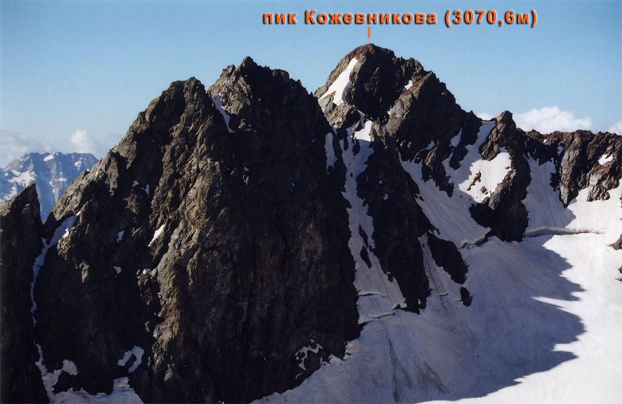
17 - (photo "Kozhevnikov Peak - view from the slopes of Igolchaty Zapadny Peak")

18 - (photo "Kozhevnikov peak - view from the northern side of the Aishkho-1 pass")
From the Kozhevnikov Peak to the north-east and further to the east, a spur extends, ending with a peak of 2936.2 m. The length of the spur is about 1 km. From the nodal mark 3004.2 m the ridge goes south to the Aishkha pass (3.7 km). In addition to the ridges described above, in the Pseashkho massif there is a one and a half kilometer rocky ridge with a height of more than 3000m with peaks of 3154.8m and 3168.5m.

19 - (photo "Igolchaty Glavny Peak - view from Igolchaty Zapadny Peak")

20 - (photo "Peaks Needle (Main, Western)")
This ridge separates two branches of the Pseashkho glacier (glaciers No. 35 and No. 36 according to the Catalog of Glaciers of the USSR). Peaks 3154.8 m and 3168.5 m and the previously mentioned peak 2936.2 m on the spur of Kozhevnikov Peak look very impressive from the valley of Malaya Laba. The appearance of these peaks varies greatly depending on the location of the observer. If you look at the peak of 2936.2 m from the Malaya Laba valley, near the mouth of the Mutnaya River (flows from glacier No. 36), then this peak looks like a beautiful sharp peak of a “needle” shape. Often it is called so - "Peak Needle".

21 - (photo "Igolchaty South Peak - view from the northern side of the Aishkho-1 pass")
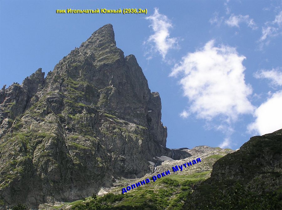
22 - (photo "Igolchaty Yuzhny Peak - view from the valley of the Malaya Laba River")

23 - (photo "Kozhevnikov peaks, Igolchaty Yuzhny - view from the Malaya Laba river valley")
(drawing "View of the Iholchatye peaks from the Malaya Laba valley (from different points)")
The top of 3154.8m visible to the right also looks like a rock tower. In order not to get confused in the names of these peaks, it is proposed to name the highest of the three peaks - 3168.5 m - as "Igolchaty Main Peak". The top of 3154.8 m is proposed to be called "Igolchaty Zapadny Peak", and the top of 2936.2 m in the spur of Kozhevnikov Peak is called "Igolchaty Peak South".

24 - (photo "Igolchatye peaks, Pseashkho glacier - view from the Pseashkho nodal shoulder")

25 - (photo "Igolchaty Glavny peak - view of the ascent to the Stroitel pass")
The Pseashkho massif is interesting for its glaciation. Here you can count 11 glaciers, of which the Pseashkho glacier (glacier No. 35) is the largest glacier in the Krasnodar Territory. This is a karovo-valley glacier 3 km long and 1.5 km 2 in area. With its upper reaches, it merges with the neighboring (to the south) glacier No. 36 (area 1 km 2), as if saddling the ridge separating them. Such glaciers are called transitional. The saddle separating glaciers No. 35 and No. 36 (ice divide) is at the same time a pass called Neftyanik (2936.8 m, 1B).

26 - (photo "Pseashkho glacier, Neftyanik pass - view from the key shoulder of Pseashkho")

27 - (photo "view to the east from the Neftyanik pass")
Glaciers Pseashkho and No. 36, like other glaciers in the Caucasus, are shrinking in size. Parts of the glaciers that are well illuminated by the sun are especially susceptible to intensive melting, while the shady parts of the glaciers are in more favorable conditions. The Pseashkho glacier melts especially intensively in the place where the flow of ice changes direction from northwest to east. The southern branch of the Pseashkho glacier (glacier No. 36) is exposed to solar radiation and intensively melts in the summer months in the part that adjoins the southern slope of the Igolchaty Zapadny peak. Here the thickness of the ice is only 2-3 m, and the surface of the ice in the second half of summer is literally cut by gullies with streams of melt water running in them. Pseashkho glacier (No. 35) gives rise to the Chistaya River, glacier No. 36 - to the Mutnaya River (both are left tributaries of the Malaya Laba River).

28 - (photo "Chistaya river valley")
To the north of the highest point of the massif (3256.9m) is the Marble Glacier (No. 31), which gives rise to the Marble River. The area of the glacier (1 km 2) is gradually decreasing due to the warming of the climate, and the division of the glacier into three parts is already planned.

29 - (photo "Marble Glacier (part of the glacier under the Marble Pass)")

30 - (photo "Cold Glacier (upper part) - view from the top of Jitaku")
On the northern slopes of the ridge connecting the peaks of Western Pseashkho (2899.8m), Southern Pseashkho (3251.2m) and Northern Pseashkho (3256.9m), there are several glaciers that were previously a single glacier. In the process of degradation, he broke into pieces. The extreme, eastern glacier is called Cold. This is a karovo-valley glacier No. 30 (according to the catalog of glaciers of the USSR) with an area of 0.5 km 2. Overfilling the bowl of the car, the glacier pushes its tongue through the crossbar into the valley, which is why it is called car-valley. The position of the end of the glacier changes periodically. So, in 1959, the tongue of the Kholodny glacier protruded beyond the crossbar and hung on its slope. In 1985, the tongue of the glacier moved forward and moved (according to the author's measurements) into the valley at 20 m from the foot of the crossbar. At present, the tongue of the glacier is again on the slope of the crossbar. Thus, the Kholodny glacier is apparently a weakly pulsating glacier. Approaching the tongue of the glacier is dangerous because of the possibility of falling rock fragments and collapses of blocks of ice. The Kholodnaya River flows out of the Kholodny Glacier and flows into the Urushten River.

31 - (photo "Kholodnaya river valley - view from the upper Pslukhsky glacier")

32 - (photo "Source of the Kholodnaya River")
To the west of the Kholodny glacier, glaciers No. 29 and No. 28 are located, connected to each other by a narrow strip of ice, which may disappear in the coming years, and the glaciers will completely separate from each other. Glaciers No. 29 and No. 28 are of the car type. Glacier No. 29 (we will conditionally call it "Medium Cold") has an area of \u200b\u200bonly 0.1 km 2. The lower part of the glacier is heavily broken by cracks, ice collapses can occur here, so it is dangerous to be below the glacier.

33 - (photo "Pseashkho glaciers - view from the Dzitaku ridge")
Glacier No. 28 (let's call it "Western Cold") has two branches flowing around Razdelnaya Peak (2700.5 m) with currents to the northwest (large branch) and north (smaller branch, with an area of 0.1 km 2). total area glacier - 0.5 km 2.
A remarkable feature of the glaciation of the massif of Mount Pseashkho is that the first glaciers from the west of the southern macroslope appear here. Greater Caucasus. These glaciers are located at the headwaters of the first and second left tributaries of the Pslukh River. There are four glaciers in total. The largest of them is the Sakharny kar glacier, which occupies part of the kar and the steep northwestern slope of Sugar Loaf Mountain (3188.9 m). Its area (according to the measurements of the author) is 0.131 km 2, the mark of the upper point is 2800 m, the lower point is 2611 m.

34 - (photo "Sakharny glacier - view from the pass
Builder")

35 - (photo "Sakharny glacier - view from the Stroitel pass")
Three other glaciers (Pslukhsky glaciers) used to be a single glacier, which broke up into three parts in the process of degradation.

36 - (photo "Pseashkho North, South - view from the Achishkho ridge")

37 - (photo "Pseashkho North, South - view from the horizon of Khmelevsky")
The Upper Pslukhsky glacier can be attributed to the morphological type of caro-hanging glaciers. The glacier has a convex surface shape, it is clearly visible from Krasnaya Polyana, resembling a sail filled with wind. The lower part of the glacier has a steepness of 50°, the upper part is much flatter. The area of the glacier is 0.052 km 2, the mark of the lowest point is 3030 m, the highest point is 3200 m. Approximately 100 m from the end of the glacier, an arcuate shaft of the terminal moraine is clearly visible. The flow from the glacier is carried out into two river systems (through depressions in the ridges bordering the glacier from the north and south): into the second tributary of the Pslukh (Mzymta river basin) by filtration through moraine deposits and into the Kholodnaya river (Urushten river basin) in the form of a stream flowing out from the north side of the glacier.

38 - (photo "upper Pslukhsky glacier")
The Middle Pslukhsky glacier is the most unusual of the Pslukhsky glaciers. It is difficult to attribute it to any morphological type. The glacier is an ice ridge, sharp in places, stretching across the valley with steep ice slopes in both directions and flow into both the first and second tributaries of the Pslukh. At the foot of both ice slopes there are two small lakes. western lake sprung by the shaft of the terminal moraine. The area of the middle Pslukhsky glacier, like the other two, is small - only 0.062 km 2 (according to the author's measurements). mark lowest points: 2909m (foot of the western slope) and 2955m (foot of the eastern slope). The mark of the highest point of the glacier is 3021m (the ice ridge at the top is 3053m). One more thing can be noted interesting feature Middle Pslukhsky glacier. As a rule, small glaciers are located in the bottoms of kars and other recesses of the slopes, where snow accumulation is better, there is more shading and, therefore, the impact of solar radiation on the glacier is less. All this contributes to better conservation of glaciers. A different picture is observed on the Middle Pslukhsky glacier: its main part is on a hill and is well illuminated by the sun at any time of the day. It can be assumed that the stability of the glacier is ensured by abundant food due to snowstorm transport of snow associated with the peculiarities of the local circulation of air masses. Therefore, the glacier itself can be attributed to the genetic type of ridge-influenced ones.

39 - (photo "middle Pslukhsky glacier")

40 - (photo "middle Pslukhsky glacier")
The lower Pslukhsky glacier (karovoy), with an area of 0.067 km 2 (according to our measurements), descends to a mark of 2754 m and feeds the first tributary of the Pslukh. The highest point of the glacier is 2903m. His western edge the glacier rests against a powerful arched moraine shaft. Comparison of photographs of the Lower Pslukhsky glacier taken by the author in 1959 and 1985 shows that the glacier has changed little or not at all during this time, its position is rather stable.

41 - (photo "Pslukh glaciers, the first tributary of the Pslukh - view from the top of Perevalnaya Yuzhnaya")
The massif of Mount Pseashkho is very popular with tourists and climbers; interesting routes. However, it should be remembered that in order to visit the Pseashkho region, it is necessary to issue a pass at the administration of the Caucasian Reserve, and the sports training of groups and equipment must correspond to the category of difficulty of the route being traveled. It is also necessary to register the group with the rescue team in Krasnaya Polyana.
One of the most popular routes in the area is Sugar Loaf Peak (3188.9m).

(topographic map "route to Pseashkho Sakharny")
In summer the route is rated 1A. From Pikhtovaya Glade on the Psekokho Ridge (on modern maps the ridge is erroneously called “Psekhako”) we climb the path to the Bear Gates and then go to the Bzerpinsky cornice to a small house built here in 2004. We continue along the path towards the Pseashkho pass and, after passing 1.5 km, we turn down the path to the right. Even from a distance, you need to make out the path on the southern slope of the Western Pseashkho mountain and outline a landmark to which you should go.
(drawing "view of the Pseashkho massif from the slopes of Mount South Perevalnaya")

42 - (photo "mountain Pseashkho - view from Perevalnaya South")
Having crossed the upper reaches of the Pslukh ford or over stones, we go to the beginning of the trail. After entering the trail, there are usually no problems with orientation - the trail is quite clearly laid along the most gentle part of the slope. Walking with a smooth climb, we cross the stream, then we approach the 1st tributary of the Pslukh. The tributary flows in a trough hanging valley, abruptly ending with its mouth to the valley of the Pslukh River.

43 - (photo "the first, second tributaries of the Pslukh - view from the Bzerpi ridge")
A steep descent down, a crossing over a tributary and an ascent to its left-bank slope. Here, under a low flat rock, there is a good campsite. Move on. A steep ascent along the slope, and again the trail passes in a traverse with a smooth climb. Descent to the 2nd tributary of the Pslukh, crossing it and climbing to the grassy areas of the left-bank slope. The trail is over. Here, at an altitude of about 2150m, you can set up a camp.

44 - (photo "camp at the foot of the western ridge of Pseashkho Sakharny")
The path to the top of Sugar Loaf Peak (3188.9 m) goes along its western ridge. The horizontal distance to the summit is 2.5 km, the elevation difference is about 1000 m. The ridge is overgrown with grass, in some places with rhododendron, there are rock outcrops.

45 - (photo "the second tributary of the Pslukh River")

46 - (photo "the second tributary of the Pslukh River")
Not reaching the steep rises of the ridge (approximately the middle of the ridge), we turn to the right, cross the snowfield and go out to the southwestern ridge. On this heavily destroyed simple ridge we reach the top.

47 - (photo "Pseashkho Sakharny - view from the Aibga ridge (third circus)")

48 - (photo "panorama to the east from the top of Pseashkho Sakharny")

49 - (photo "Kozhevnikov Peak - view from the top of Pseashkho Sakharny")
From the top, a beautiful panorama of near and distant mountains opens: Pseashkho (Uzlovoi, Southern, Northern), Needle peaks, Green wedge, Kozhevnikov peak, Tsakhvoa, Agepsta, Ah-Ag, Aibga, Achishkho, Chugush and others. Akhun, Bytkha, the city of Sochi, the Black Sea are visible. When descending from the summit along the southwestern ridge, one can mistakenly, especially in fog, turn onto the southern ridge adjacent to it. To prevent this from happening, when ascending, you can mark the place of descent with tours of stones or other marks.
The described route to Sugar Loaf Peak is the easiest. There are more difficult routes. In 1998, Viktor Kholodilin, a climber from Lazarevsky, climbed the Sakharnaya Loaf peak along the rib from the side of the Pseashkho glacier, estimating the route with a difficulty category of 3A-3B. In July 2000, Artur Brikalov, a Tuapse climber, made a traverse: Sugar Loaf peak - Green wedge - nodal mark 3004.2 m - Kozhevnikov peak. The category of difficulty of the route according to his assessment is 2B.
Another, no less popular, route leads to the Uzlovoe Shoulder (3192m) of South Pseashkho. Route difficulty category - 1A, length (from the camp near the Sugar Glacier) - 1.4 km, climb - 540 m. The beginning of the route to the 2nd tributary of the Pslukh is described above.

50 - (photo "the path to the Sakharny glacier along the valley of the second tributary of the Pslukh River")
Then we go up the valley of the tributary towards the Sakharny glacier. The glacier itself is not visible, it is closed by a crossbar (2650m), which, with its steep slope, blocks the valley of the 2nd tributary. Further, the path goes up overgrown with grass and rhododendron moraine. The main tributary flowing from the Sugar Glacier remains on our right. On the left is a powerful stream with waterfalls. The moraine, along which we climb, adjoins the left (when viewed from below) edge of the crossbar. Here the ascent goes along a weakly marked path. It is necessary to climb carefully - on the left, the slope breaks off steeply to the stream. Behind the crossbar there are good sites for the camp, behind them - the lower bowl-shaped part of the Sahara Glacier, and further - the saddle of the Stroitel Pass (2815m, 1B). From the camp you can go through the Stroitel pass to the Pseashkho glacier.

51 - (photo "approximate route to the Stroitel pass from the Sakharny glacier")
The slope along which they climb to the pass seems steep, but, in fact, it is easy to pass. To the left of the pass Builder you can clearly see the Nodal Shoulder (3192m). The path to it (from the camp near the Sakharny glacier) goes along the scree slope of the left bank of the stream. At the very end of the ascent along the stream, where the channel deeply cuts into the ridge, the movement is somewhat complicated by the steepness and unstable stones lying on the scree. Having crossed the incision of the stream, we exit to the Middle Pslukhsky glacier with a small lake at the foot of the steep eastern slope, and on the right, 300 meters away, the Upper Pslukhsky glacier hangs with a steep ice wall, bordered on the right (from the south) by a not steep, strongly destroyed ridge. On this simple ridge, climbing from one rock block to another, we reach the top of the Uzlovy Shoulder (3192m).

52 - (photo "Pseashkho Sakharny - view from the nodal shoulder")

53 - (photo "panorama to the north from the top of Pseashkho Sakharny")
If you go along the ridge further to the north, leaving the Upper Pslukhsky glacier on the left, you can reach the Uzlovaya Peak (3196m). When moving along the ridge along the upper edge of the glacier, you need to be careful (ice ax at the ready!), As in case of a fall, you can slip down, where the steepness of the glacier is 50 ° and it will be problematic to stay.
Following from the nodal peak further along the ridge to the east, after 500m you can reach the peak of South Pseashkho (3251.2m). At the top there is a metal pyramid - a triangulation point (heavily damaged by winter snow and wind). This route has a higher category of difficulty - 1B.

54 - (photo "South Pseashkho summit - view from Pseashkho Sakharny")

55 - (photo "Pseashkho South - view from the nodal shoulder")
Sometimes tourists, having climbed the Uzlovoe Shoulder, believe that they have reached the summit of the Southern Pseashkho, and, having climbed the Southern Pseashkho, they think that they have ascended the Northern Pseashkho. This mistake can be easily eliminated, remembering that a pyramid is installed on the top of the South Pseashkho, while there is no pyramid on the North Pseashkho.
You can also reach the Knot Shoulder by other, more difficult routes. If you go up the valley of the 1st tributary of the Pslukh, you will have to overcome a simple wall, on which the tributary breaks into three branches, forming waterfalls. Next, you need to overcome the steep slopes of the Pslukhsky glaciers - the Lower and Middle (cats, ice ax!). After descending from the Middle Glacier, the ascent path coincides with that described above. Route difficulty category - 1B.
Another route (also 1B) runs along the ridge of the watershed ridge separating the basins of the 1st and 2nd tributaries of the Pslukh with access to the western ridge of the Uzlovy Shoulder. The route is somewhat tiring, with numerous rock climbs and, in the first half of summer, a sharp snow scallop.
From the camp near the Sakharny glacier, you can go to the Igolchaty peaks through the Stroitel pass (2815, 1B). From the pass they go along the Pseashkho glacier (cats, ice ax!) to the Neftyanik pass (2936.1 m, 1B) and then traverse the slope of glacier No. 36 in the direction of the southern spur of the Igolchaty Zapadny peak (3154.6 m). On a simple, mostly scree and heavily destroyed ridge of the southern spur, they rise in a northerly direction to the top of the peak. Difficulty category - 1A.

56 - (photo "the way to the Iholchaty Zapadny Peak")
The traverse of two peaks is more difficult: Needle Western - Needle Main. Brikalov A.F., who passed this route, evaluates it with 2A category of difficulty.
Simple routes (not higher than 1A) lead to the peaks of Razdelnaya (2700.5m) and Kamenny Zamok (2556.0m), subject to climbing along their southern ridges (from the north, these peaks are quite difficult to climb). The problem here is different - the complexity of the approaches.

57 - (photo "the left tributary of the Kholodnaya River")
The path along the left tributary of the Kholodnaya River (flowing from glacier No. 28) is rather unpleasant in its lower part. Walking along the right bank of the tributary (leaving the waterfall on the right), one has to wade through thickets of crooked forests without a path. After entering the tributary valley, you should go in the direction of a large stone and then to the "ram's foreheads" with a small lake. The next obstacle is a rock barrier. In its left part there is a shelf with a path trodden by tours. Above the trail is lost, you have to overcome steep cliffs. This is followed by a simpler and gentler ascent to the northern edge of glacier No. 28. Along a gentle moraine along the edge of the glacier, we move east to the southern simple ridge of Razdelnaya (here glacier No. 28 is divided into two branches - northwestern and northern). There is an easy access to the summit along the ridge (2700.5m). Going around Razdelnaya from the east, they go down to the Stone Castle and go along a very light, almost horizontal, wide meadow ridge to highest point(2556.0m).
It is much more difficult to climb to the highest point of the entire massif - Northern Pseashkho (3256.9m). There is no easy way to this peak. Below is a description of one of the ascent options (along the route covered in July 1998 by A. Brikalov - B. Tarchevsky). The difficulty category of the route is approximately 2B-3A.
(drawing "ascent route to Pseashkho North")
From the Kholodny camp, along the right-bank path along the Kholodnaya River, they go southeast. Before reaching the mouth of the Marble River, the path begins to take to the left (in the direction of rocky cliffs) and, gaining height, leads to the valley of the Marble River. Having crossed the river, we climb the meadow, scree and snowy slopes, through the snow bridge between two rocky ridges to the western part of the Marble Glacier, to the moraine at the foot of the Pseashkho rocky teeth (2936.4m). From the moraine we climb the steep slope of the Marble Glacier (cats, ice ax!) bypassing the cracks and further to the left to the saddle in the lower part of the northern ridge of the summit (leaving the northwestern ridge on the right).
From the saddle, the ridge rises with a steep rise. We go around it on the left along the shelves, then go up to the ridge. Along the ridge with sharp rocks in the form of feathers, bypassing them on the left along the slab, we exit between two "gendarmes". Again bypassing the ridge on the left along the shelves, exit to the ridge and then up the steep rise of the ridge. Here the crest again becomes sharp and jagged, but on the right there is a detour along shelves and screes. To the right is a small grotto. We go around the top wall on the right and along a simple scree slope we reach the highest point of the entire Pseashkho massif (3256.9 m).
From the top there is a magnificent panorama of the mountains. Below, under your feet - the glaciers of Pseashkho, Kholodny, Marble, the green valley of the Kholodnaya River, the sharp Teeth of Pseashkho. The South Pseashkho with a pyramid on top is clearly visible; a rocky ridge bristling with towers and teeth leads to it. In the southwest, through the mist, one can discern Mount Akhun and even Bytkha with white dots of houses. Endless chains of mountains with bizarre patterns of glaciers and snowfields sparkling in the sun go to the east. The world of silence, grandeur and beauty!

B. A. Tarchevsky
Photos: KOT / R4 / PNL Krasnodar, D. Komarov, Sochi
» (SPL) is an online service for the selection of unique insurance programs for sports enthusiasts and active rest, where you can always find current offers from the best insurance companies.
Off-piste skiing skiing or snowboarding requires special preparation before going on snowy slopes, especially if you are skiing outside the resorts where their rescue services are responsible for you.
Especially for the Yeti Guide Bureau, we have prepared recommendations for issuing insurance policies for freeride, backcountry, heli-skiing and ski tours, depending on the ski area.
What kind of insurance policy should I have for off-piste skiing?
Option I - TCD insurance policy
Insurance policy for traveling abroad (VZR) * or traveling in Russia, as a rule, includes:
Medical expenses:
For outpatient treatment, stay and treatment in a hospital, including diagnostics.
Medical transport costs:
On search, evacuation (transportation by ambulance or other appropriate medical condition vehicle, including by helicopter) from the scene of the incident in the territory of temporary stay to the nearest medical institution or to a doctor located in the immediate vicinity;
Transportation of the Insured Person from one clinic to another in case of medical necessity;
For emergency medical repatriation from the territory of temporary stay by a vehicle corresponding to the medical condition, including expenses for the accompanying person.
Travel expenses (return ticket home, etc.)
Hotel accommodation expenses
Posthumous repatriation expenses
Additional costs (may be telephone charges, baggage loss insurance, civil liability insurance, etc.)
* When traveling through the territory of the Russian Federation, it is important to know that under the terms of insurance of insurance companies, the administrative and territorial unit indicated in the policy as the Territory of Insurance, must not be the place of permanent residence of the Insured. For persons permanently residing in Russia and / or having Russian citizenship - this is the administrative-territorial unit in which the Insured is registered: city, rural settlement (village, village, farm, aul, rural-type settlement, etc.), settlement and a subject equal to them in the level of classification. You should always carefully look at the insurance rules of each insurance company. companies.
Price insurance policy depends on the choice of the insurance company, insurance conditions, geography of skiing, age of the Insured, type of sport.
On average, the cost of a VZR policy for freeriding in Russia varies from 400 R per day.
II option - policy "Accident" (NS)
This is a type of voluntary insurance, when in case of injury or acute poisoning, temporary disability, disability or death of the Insured person as a result of an accident, the Insurer makes an insurance payment upon application within the limits of the sum insured specified by the contract.
In the event of an insured event, the insurance benefit is calculated as a percentage of the sum insured for the given risk according to the Table of Insurance Benefits.
For example: if you bought an Accident policy of IC "Consent" with insurance coverage of 500,000 R, then in case of a shoulder fracture and tendon rupture, a payment will be made to the Insured in the amount of 20% of 500,000 rubles, which will be 100,000 R. The cost of such a policy will be 200 R per day.
This type of insurance program is suitable for those who live and ride in the area of the administrative-territorial unit in which he is registered, and this policy is cheaper than the TCD policy.
Also, the accident policy is suitable for those who ride in the zone ski resorts where first aid is provided by resort rescue services.
III option - Combined insurance policy (VZR + HC)
The combined insurance policy consists of HC + TCD described above.
Under this insurance policy, you will receive not only a list of services rendered on the spot, but also monetary compensation according to the Table of Insurance Benefits.
So which policy should I choose for off-piste?
The choice of a suitable type of insurance primarily depends on the place of permanent residence of the Insured and the ski area.
When should I take out an insurance policy?
You need to issue an insurance policy on the eve of the day of skiing, it is impossible to issue a policy on the same day.
Can I cancel my insurance policy if I am unable to participate in the program?
If you have issued an accident policy of IC "Consent" - then you can cancel it the next day when you cancel your participation in the program. The money for the policy is returned in the amount of 100%.
If you have taken out a VZR or VZR + NS insurance policy, then the possibility of canceling the insurance policy and returning Money on it depends on the rules of insurance of the insurance company.
Can I insure a child?
Yes, you can insure your child under any type of insurance. To do this, some insurance companies may require personal data of parents.
You can apply for an insurance policy on the website www.saveprolife.ru and receive it by e-mail, as well as call 8 800 250 87 58.
Important! The insurance policy must take into account the chosen sport!
Remember! CHI provides primary health care, emergency medical care (with the exception of specialized (sanitary and aviation) emergency medical care), and specialized medical care.
These lands were new for us, we went in the direction of Kardyvach, but not here yet.
On the way from Pikhtovaya Polyana to the Bzerpsky cornice, one could admire all the ski slopes that are in Krasnaya Polyana. I took a photo of the Rosa Khutor tracks, which are still being prepared.
Finally, the Bzerp cornice:


Beautiful there! And the views from the "cornice" are good:

About animals (not wild :): from Gazprom itself, two dogs became attached to us, we called them Belka and Strelka. Such businessmen ran, sort of like on their own business, but at the same time they followed us. At the halt, Strelka fell asleep, and Belka ran on with us. A large group of young men and women stomped behind us, led by an adult leader (those lagging behind were terribly whining))), and now after some time we see - Strelka woke up, caught up with them and runs further :) In this photo on the right you can see dogs, and We couldn't take more pictures of them: the inhabitants of the house were indignant that we were violating the reserved regime and dragged them here. To which we objected that we didn’t invite them here, and the dogs were driven down, but it’s a pity, I managed to become attached to them, and in general it was fun to go in their company, although, on the other hand, we still don’t have food for them It was:)

But I didn’t have to miss the living creatures for a long time, because. The Stupid Horse followed us :) Later, we learned that he literally followed all the tourists, interfered with some of them to have dinner, trying to steal food directly from the bowl, we also found out that the animal eats lard and sausage, is not inclined to bring benefits and is nicknamed Geser (it seems that this is from the Day or Night Watch, I don’t understand them :)) We drove him away as best we could, but he didn’t care. It turned out that we tried in vain: he didn’t want to climb far into the Pslukh valley himself, he liked hanging out along the Bzerpi, there are more people there, there is someone to pick up :))

The sharp cone of Pseashkho Sakharny was visible along the way, and it seemed completely unrealistic that tomorrow we would be there at the very top - for some reason it always seems so :)

We turned into the valley of Pslukh, the path went on top, leaving the river far below. It was getting cloudy, I don’t have any good photos of this area. The first tributary of the Pslukh had to be forded.

The second tributary could be crossed over a snow bridge. Behind him we set up camp. Along the way we met good man Misha and his family, including little Tatiana, who had already been in the mountains several times, carried her own backpack and was generally great :) Misha also wanted to climb Pseashkho, and we decided to spend the night together and climb the four of us in the morning.
Got up at half past five. Opened from the camp good view on Agepsta, Turya Gory and Aibga.


It was necessary to go horizontally only some 2-3 kilometers, but climb 1000 meters up :)
The camp lay in the shade, and during the ascent, the sun suddenly hit right in the face.


Chugush appeared.


Slowly clouds began to appear. We must have left too late. But there is still visibility. And it's far from the top... :)


Finally got in!


I did not make a circular panorama, because it was too cloudy from the northwest.


The note on the top was already October. Looks like we're not the only ones who forget to take a pen with us :) There was nothing to write our own, we did not shoot this one, we returned it to its place.


We sat just a little and it's time to go down, as if not to fall into the fog.


There were more and more clouds, and several times we rested, sitting on the ridge and watching them rise from the valleys, thicken and disperse, open and close the views around, go from right to left, left to right, top to bottom ... It was like 3D movie on big screen :)
The next photo is very remarkable, and I know a couple of people who will be happy with it)))) I lay down and say something like: “Oh, how wonderful these flowers smell!” And Mitya says: “Anya, you are lying with your head right in the turkey poop!”)))

Our top was sometimes opened so that we could see where we had just been.

Here we can see our camp.


We need to pack up and go, but I really want to sit idle ... :)

In general, we wanted to reach the Jitaku lakes that day. But we got down from the top quite late. The ascent took 4 hours, the descent - I do not remember. We decided - let's go, as far as we can get.
The clouds descended into the valley of Psluh, and then the sun came out again.


Further, our path lay through the Pseashkho pass. I really wanted to see this pass. It is of the valley type. That is, you walk, you walk along the valley, and you don’t notice any passes at all. But flowing water (and also a cyclist :)) notices any slope. And now the streams running down from the mountains flow towards you, to the south. And after some invisible point, new streams begin to run with you along the way - to the north. At this very point, the southern and northern slopes of the Western Caucasus are divided, so different! The waters of those streams will fall into the Black Sea, and these - into the Kuban.
We are a little tortured at the point where the pass is marked on the map:

We spent the night at Maloye Lake, deciding to run to the rest of the lakes in the morning, if the weather permits. I don’t have a lake in the photo, but there is a Magnificent Bump! This stream flows from the lake and flows into the nearby Urushten. The bump conquered me, I didn’t even step on it to cross this “groove” :)

In the morning it was raining and foggy, and we decided to leave the lakes for another time. Or rather, there was nothing to decide - it was so nice to set the alarm clock two hours ahead and sleep even under the sound of rain ... we barely woke up :)

Here are some other stones in the creeping fog that I came across interesting:
And on the way back there wasn't much to see.
We went on a four-day light-hike in the Caucasian Biosphere Reserve. I wanted to finally get away from Krasnaya Polyana and go to some top 3000+. The final route turned out as follows: climbing the Gazprom cable car to Pikhtovaya Polyana - climbing the Medvezhye Vorota pass - a camp in the upper reaches of the Pslukh River - climbing Mount Sugar Pseashkho (3169 m) - a walk through the Pseashkho pass to the Kholodny camp - the Semiozerka valley - returning through the Medvezhyi Vorota and Fir Glade back to the cable car.
Starting at lunch from the upper station of the Gazprom cable car, in the evening we went to the Bzerpinsky cornice
Already in the first hours of the hike, it became clear that we were not mistaken with the choice of time for the hike!
Everything blooms in the mountains, including rhododendron
In a wonderful house on the Bzerpinsky cornice, the employees of the reserve are based, who once again checked our documents on the first day of the trip. The reserve is locked, you can't slip through! And it is right.
Trail to the valley of the river Pslukh and to the pass Pseashkha
In the valley of one of the tributaries of the Pslukh River, we met a sympathetic bear. He was sitting under a rock and apparently guarding a herd of five roe deer, which was grazing above. Seeing us, Taptygin hastily retreated :)
In some places, snow even lies below, in narrow valleys.
Sugar Pseashkho (on the right) has finally appeared - today's goal!
By 9 am, we finally got to the western ridge of Sakharny Pseashkho. From here begins the actual ascent!
Three hours of ascent, and now, finally, the last meters to the desired peak!!!
Yura at the summit tour of Sugar Pseashkho
The descent from the mountain took place in difficult weather conditions! Without GPS, it would be oh so difficult to find the descent couloir ..
After climbing Sakharny Pseashkho yesterday, we decided to rest and take a light walk to the Kholodny camp.
Meadow flowers on the Pseashkha pass (2014 m)
Ford across the Kholodnaya River near the camp of the same name. A brand new suspension bridge a hundred meters from the ford was noticed only on the way back :)
We were not alone in the Kholodny camp. We met with the guys who have been living here for more than two weeks. Building new houses, pulled a new bridge. One of these days they are waiting for a helicopter to fly to a new place. In general, life is in full swing, the reserve is developing. Actually, it's all great! With such infrastructure, tourism becomes more accessible. I hope too, more people will go to the mountains instead of sitting at the television :)On the way back we "ran" to the Jitaku Valley
On the pass Yurka, like an old yogi, practiced in the formation of clouds
Valley of the river Urushten
Our camp in the canyon of the Pslukh stream
In the evening there was a delicious cheese soup with onions in the bite!
The final, fourth day did not promise great difficulties. Having gained only about 100 meters of height, we again returned to the house on the Bzerpinsky cornice, from where we went to the upper station of Gazprom in two hours. then boarding the bus and a long two-hour road through traffic jams to Sochi. In the evening, a long-awaited shower, a bowl of hot soup and a bottle of red dry!On the Bzerpa cornice with tourists from Maikop
Descent through the magical forest to the cable car
Hike TimingDay one, June 22 12:00 - climbed on the cable car to the upper station of Gazprom 13:40 - having lost a lot of time, they hardly passed the Olympic construction site and went to the dirt road leading to the Bzerpinsky cornice 15:00 - 17:00 - lunch break 18:30 - went up to the house on the Bzerpinsky cornice 20:30 - set up a camp at the bottom of the canyon of a tributary of the river Pslukh Day two, June 23 06:00 - left the camp 08:30 - went to the western ridge of Sakharny Pseashkho 9:45 - 10:30 - transition to the southwestern ridge of Pseashkho by traverse of the western slope 12:00 - 13:00 - rest on the top of Saharny Pseashkho 18:30 - return to the camp Day Three, June 24 10:00 - left the camp 10:30 - Pseashkho pass 12:30 - 15:30 - rest in the Cold camp, lunch, swimming in the river 17:00 - Jitaku Pass 19:30 - return to the camp Day Four, June 25 10:00 - left the camp 10:40 - Bzerpinsky cornice 13:00 - the upper station of the cable car Gazprom "Laura" An important note on the timing of the campaign:in order to get the necessary time for the passage of a particular section of the route, we can safely divide by two the time we spent. We walked very slowly, took a lot of pictures, were absolutely in no hurry, and besides, I also got sick on the second day of the trip (even in Sochi it blew under the air conditioner). So tourist groups moving "in sport mode" will go through all this faster!Map of the hike to Sakharny Pseashkho and the Kholodny camp
Original route map Key point coordinates GPS01 (upper station of the cable car "Laura" Gazprom) - 43°41"37.61"N, 40°18"49.28"E, GPS02 (beginning of trail) - 43°41"39.44"N, 40°21"1.43"E GPS03 (house on the Bear Gate Pass) - 43 ° 42 "34.25" N, 40 ° 22 "36.13" E, GPS04 (turn of the trail to Sakharny Pseashkho) - 43°43"18.23"N, 40°23"3.99"E, GPS05 (beginning of the traverse of the western slope, transition to the southwestern ridge) - 43 ° 42 "32.05" N, 40 ° 25 "50.74" E GPS06 (point of exit to the southwestern ridge of Pseashkho) - 43°42"20.09"N, 40°26"10.44"E, GPS07 (top of Saharny Pseashkho) - 43°42"31.15"N, 40°26"39.42"E, GPS08 (beginning of the upper trail to the Semiozerka valley) - 43°44"3.00"N, 40°23"28.08"E GPS09 (the place of the ford Urushtena for access to the Semiozerka valley from the side of the Kholodny camp) - 43 ° 45 "16.88" N, 40 ° 24 "23.32" E, GPS10 (new suspension bridge over the Kholodnaya River) - 43°45"34.30"N, 40°25"1.01"E, GPS11 (House camp Cold) - 43 ° 45 "47.16" N, 40 ° 25 "3.42" E, GPS12 (viewpoint on the Semiozerka pass) - 43°45"15.73"N, 40°22"34.19"E. Actual track for navigatorsGarmin -Legend: 1 - upper station of the cableway "Laura" Gazprom, 2 - Medvezhiy Vorota pass (n/a, 2100 m), 3 - traverse of the western slope of Mount Sakharny Pseashkho, 4 - peak of Mount Sakharny Pseashkho (n/k, 3188 m), 5 - Pseashkho pass (n/c, 2014 m), 6 - Kholodny camp, 7 - Semiozerka pass (n/c, 1920 m).
Tour budget (in terms of 1 person)- Pass to the reserve, for 5 days - 750 rubles.
- Products for 5 days of the hike - 800 rubles.
- Gas - 150 rubles.
- Minibus Sochi - Krasnaya Polyana (Gazprom cable car) - 100 rubles.
- One ascent + one descent cable car"Laura" - 600 rubles.
- Minibus Krasnaya Polyana (Gazprom cable car) - Sochi - 100 rubles.
- Total: 2500 r.
Pass to the Caucasian State Biosphere Reserve. There are two points to be aware of. First, you will need a pass from the reserve. Secondly, if you are going to the area of Lake Kardyvach or the Aibga Ridge and the area of the Tury Mountains, then you additionally need to get a pass from the border guards!
findings
Very beautiful! Especially the section from the Bear Gate Pass to the Pseashkho Pass I was very surprised by the cleanliness of the route. No beer cans or wrappers. Respect to the staff of the reserve (and tourists?)
Excellent trails and equipped parking lots on the Bzerpinsky cornice and in the Kholodny camp
Thanks to all the above factors, the area is ideal for exploring the mountains and the first trips!
For myself, I will definitely leave this area as one of the best for short training trips in style. fast&light
Be sure to go skiing here in winter.
Source - http://www.mountain.ru
You will find a detailed description of the route, a map showing trails and possible radials (with GPS coordinates), as well as a description of the weather and the most up-to-date information on obtaining passes for this route. Here - brief information for this specific trip.
Route map in Google Earth
Legend:
A B- the beginning of the trail, the entrance to the territory of the Caucasian Reserve, C D- overnight place E F G- Cold camp. H
Hike Timing
- 12:00 - climbed on the cable car to the upper station of Gazprom
- 13:40 - having lost a lot of time, we barely passed the Olympic construction site and went to the dirt road leading to the Bzerpinsky cornice
- 15:00 - 17:00 - lunch break
- 18:30 - went up to the house on the Bzerpinsky ledge
- 20:30 - set up a camp at the bottom of the canyon of a tributary of the river Pslukh
- 06:00 - left the camp
- 08:30 - went to the western ridge of Sakharny Pseashkho
- 9:45 - 10:30 - transition to the southwestern ridge of Pseashkho by traverse of the western slope
- 12:00 - 13:00 - rest on the top of Sugar Pseashkho
- 18:30 - return to the camp
- 10:00 - left the camp
- 10:30 - Pseashkho pass
- 12:30 - 15:30 - rest in the Cold camp, lunch, swimming in the river
- 17:00 - Jitaku pass
- 19:30 - return to the camp
- 10:00 - left the camp
- 10:40 - Bzerpinsky cornice
- 13:00 - upper station of the cable car Gazprom "Laura"
An important note on the timing of the campaign: in order to get the necessary time for the passage of a particular section of the route, we can safely divide by two the time we spent. We walked very slowly, took a lot of pictures, were absolutely in no hurry, and besides, I also got sick on the second day of the trip (even in Sochi it blew under the air conditioner). So tourist groups moving "in sport mode" will go through all this faster!

Legend:
1 - the upper station of the cable car "Laura" Gazprom, 2 - Medvezhiy Vorota pass (n/a, 2100 m), 3 - traverse of the western slope of Mount Sugar Pseashkho, 4 - the top of the mountain Sugar Pseashkho (n / a, 3188 m), 5 - Pseashkho pass (n / c, 2014 m), 6 - Camp Cold, 7 - Semiozerka pass (n / c, 1920 m).

Key point coordinates
- GPS01(upper station of the cable car "Laura" Gazprom) - 43°41"37.61"N, 40°18"49.28"E,
- GPS02(beginning of trail) - 43°41"39.44"N, 40°21"1.43"E
- GPS03(house on the Bear Gate Pass) - 43 ° 42 "34.25" N, 40 ° 22 "36.13" E,
- GPS04(turn of the trail to Sakharny Pseashkho) - 43°43"18.23"N, 40°23"3.99"E,
- GPS05(beginning of the traverse of the western slope, transition to the southwestern ridge) - 43 ° 42 "32.05" N, 40 ° 25 "50.74" E
- GPS06(point of exit to the southwestern ridge of Pseashkho) - 43°42"20.09"N, 40°26"10.44"E,
- GPS07(top of Saharny Pseashkho) - 43°42"31.15"N, 40°26"39.42"E,
- GPS08(beginning of the upper trail to the Semiozerka valley) - 43°44"3.00"N, 40°23"28.08"E
- GPS09(the place of the ford Urushtena for access to the Semiozerka valley from the side of the Kholodny camp) - 43 ° 45 "16.88" N, 40 ° 24 "23.32" E,
- GPS10(new suspension bridge over the Kholodnaya River) - 43°45"34.30"N, 40°25"1.01"E,
- GPS11(House camp Cold) - 43 ° 45 "47.16" N, 40 ° 25 "3.42" E,
- GPS12(viewpoint on the Semiozerka pass) - 43°45"15.73"N, 40°22"34.19"E.
- Actual track for Garmin navigators - .gdb , .gpx
- Track for viewing in Google Earth - download

update! photos of houses in June 2014
Camping budget
(in terms of 1 person)
- Pass to the reserve, for 5 days - 750 rubles.
- Products for 5 days of the hike - 800 rubles.
- Gas - 150 rubles.
- Minibus Sochi - Krasnaya Polyana (Gazprom cable car) - 100 rubles.
- One ascent + one descent on the cable car "Laura" - 600 rubles.
- Minibus Krasnaya Polyana (Gazprom cable car) - Sochi - 100 rubles.
- Total: 2500 r.
Border pass and pass to the Caucasian State Biosphere Reserve
There are two points to be aware of. First, you will need a pass from the reserve. Secondly, if you are not going along this route, but, for example, to the area of \u200b\u200bLake Kardyvach, then you additionally need to get a border pass! It turns out that it is not easy - you must provide a photocopy of your passport and a completed application in which you indicate the desired area (areas) to visit. It seems that documents can be sent by fax, but you still have to receive them on the spot, that is, in Sochi. Passes are made free of charge, the production time is from one to two months and are valid until the end of the current year at the time of submission of documents.
General information about routes, weather and other nuances of hiking in the territory of the Caucasian Biosphere Reserve - in my self-made guide to Sochi and Krasnaya Polyana for outdoorsmen and hikers. Read it, I think it will be useful.
Addresses of the office of the Caucasian Biosphere Reserve
to get a route pass:
- Adler, Karl Marx str., 8. Opening hours: from 9-00 to 17-00, except weekends and holidays.
- Krasnaya Polyana, Aviary complex (2 km on the road from the Gazprom cable car). Working hours: from 9-00 to 17-00, without days off and holidays.
Useful information and contacts
- Transfer by jeep from Krasnaya Polyana to the barrier of the cordon of the Biosphere Reserve - Pavel (+7 918 204 4303). A professional driver, just like his father. Pavel is an ethnic Greek, as befits a real Krasnopolyan. The cost of the drop is about 1000 rubles per person, but not less than 3-4 people.
- Georgy Vitalievich (+7 928 661 5210) – senior ranger of the reserve. You can negotiate with him about horses for throwing at Kardyvach. The cost is around 3000 rubles per horse per day. You can also find out about getting a car to the Engelman Polyana or getting a pass for a particular route.
findings
- Very beautiful! Especially the section from the Medvezhiy Vorota pass to the Pseashkho pass
- I was very surprised by the cleanliness of the route. No beer cans or wrappers. Respect to the staff of the reserve (and tourists?)
- Excellent trails and equipped parking lots on the Bzerpinsky cornice and in the Kholodny camp
- Thanks to all the above factors, the area is ideal for exploring the mountains and the first trips!
- For myself, I will definitely leave this area as one of the best for short training trips in the style of fast & light
- And yet the radials rule! "In line" we would not have had time to go so much!
- I remembered an important truth - you need to be very responsible in choosing a place for the camp. Sleep and food beautiful place means a lot both for recuperation and just always a pleasure to admire beautiful view straight from the camp!
- Be sure to go skiing here in winter. UPDATE! Made! See
Related publications
-
 How are numbers assigned to public transport routes?
You can also lay the route manually, armed with a map, pencil and ruler. But if you are on the route planner page, then ...
-
 How to use your phone to know when the bus is coming
Moscow is certainly a huge city. A lot of people live here - about 12,380,664 (as of 2017) people. And this number is growing every...