
World Ocean. Sea waves

6. Sea waves.
© Vladimir Kalanov,
"Knowledge is power".
The surface of the sea is always mobile, even with complete unheard. But the wind tree, and ripples immediately appear on the water, which goes into excitement, the faster, the stronger the wind blows. But whatever strength is the wind, it cannot cause waves more than certain largest sizes.
Waves arising from wind are considered short. Depending on the strength and duration of the wind, their length and height ranges from a few millimeters to tens of meters (in the storm the length of the wind waves reaches 150-250 meters).
Observations over the sea are shown that the excitement becomes strong already at wind speed more than 10 m / s, while waves rise to a height of 2.5-3.5 meters, having rummaged with a root to the shore.
But the wind goes into stormAnd the waves reach huge sizes. On the globe many places where very strong winds blow. For example, in the northeastern part of the Pacific Ocean, east of the Kuril and Commander Islands, as well as to the east of the main Japanese island Honshu in December-January, the maximum wind speeds are 47-48 m / s.
In the southern Pacific, the maximum wind speeds are celebrated in May in the area to the northeast of New Zealand (49 m / s) and near the Southern Polar Circle in the area of \u200b\u200bBalleng Islands and Scott (46 m / s).
We are better perceived by the speeds expressed by kilometers per hour. So the speed of 49 m / s is almost 180 km / h. Already at wind speed, more than 25 m / s rise waves with a height of 12-15 meters. This degree of unrest is estimated by 9-10 points as a cruel storm.
I measurements found that the height of the storm wave in the Pacific reaches 25 meters. There are reports that there were waves with a height of about 30 meters. True, this assessment is not done on the basis of instrumental measurements, but approximately to the eye.
In the Atlantic Ocean, the maximum height of wind waves reaches 25 meters.
The length of the storm waves does not exceed 250 meters.
But the storm stopped, verse wind, and the sea does not calm everything. How the echo storm at sea occurs swell. Waves of Zybi (their length reaches 800 meters or more) moved to huge distances of 4-5 thousand km and at a speed of 100 km / h, and sometimes higher, suitable to the shore. In the open sea, low and long waves are invisible. When approaching the movement speed of the wave due to friction on the bottom is reduced, but the height increases, the front slope of the wave is made steeper, foam appears on the top, and the crest of the wave rummaged to the shore - so it occurs with a surf - the phenomenon is just as colorful and magnificent, How dangerous. The strength of the surf is colossal.
Faced with an obstacle, water takes on a large height and damages lighthouses, port cranes, grooves and other structures. Throwing off the bottom of the stones, the surf can damage even the highest and deleted from the shore of the lighthouses and buildings. There was a case when the surf ripped the bell from one of the English lighters from a height of 30.5 meters above sea level. A surf on our Lake Baikal Sometimes in stormy weather throws gamans weighing up to a ton for a distance of 20-25 meters from the coast.
The Black Sea during the storms in the Gagra area for 10 years blocked and swallowed the coastal strip of 20 meters wide. When approaching the shore, the waves begin their destructive work with a depth equal to half of their length in the open sea. Thus, with a length of a storm wave of 50 meters, characteristic of such seas, as a black or baltic, the effect of waves on an underwater coastal slope begins at a depth of 25 m, and with a wavelength of 150 m, characteristic of the open ocean, such an impact begins at a depth of 75 m.
Directions of flows affect the size and strength of marine waves. With the oncoming wavemets of the wave in short, but above, and with a passing - on the contrary, the wave height decreases.
Near the borders of sea currents, waves of an unusual shape resembling a pyramid, and hazardous waterways, which suddenly appear and suddenly disappear. In such places, visitors becomes especially dangerous.
Modern ships possess high seaworthy qualities. But it happens that, overcoming many miles on the raging ocean, ships are still more dangerous than in the sea when they come to their native bay. A mighty surf, breaking multi-torrent reinforced concrete dams, is able to turn even a large ship in a pile of metal. In the storm it is better to post with an approach to the port.
To combat the achievement, specialists have tried to use air in some ports. The steel tube with numerous fine holes was laid on the bottom of the sea at the entrance to the bay. Air under high pressure was fed into the pipe. Blowing out of the holes, the streams of air bubbles rose to the surface and destroyed the wave. This method has not yet found wide use due to insufficient effectiveness. It is known that rain, hail, ice and thickets of marine plants calm the excitement and surf.
Sailors have long noticed that the fat poured overboard smoothes the waves and reduces their height. The best animal fat is valid, for example, whale brew. The effect of the action of plant and mineral oils is much weaker. Experience has shown that 50 cm 3 oils is enough to reduce the excitement on an area of \u200b\u200b15 thousand square meters, that is, 1.5 hectares. Even a thin layer of oil film significantly absorbs the energy of the oscillatory movements of water particles.
Yes, all this is so. But, God forbid, we do not recommend the captains of the sea ships before the flight to stock up fish or whale fat in order to then pour these fats in the waves to calm the ocean. After all, so it can get to such an absurd that someone will begin to merge into the sea and oil, and fuel oil, and diesel fuel to lose the waves.
It seems to us that the best way to combat the waves is a well-supplied meteorological service, in advance of the ships of the estimated place and time of the emergence of the storm and its estimated strength, in good navigation and pilotage training of sailors and coastal staff, as well as in constant improvement of the design of ships for the purpose of Enhance their nautical qualities and technical reliability.
For scientific and practical purposes, it is necessary to know the complete characteristic of the waves: their height and length, speed and range of their movement, the power of a separate water shaft and the energy of the excitement in a particular area.
The first measurements of the waves were performed in 1725 by the Italian scientist Luigi Marsillia. At the end of the XVIII - at the beginning of the XIX centuries, regular observations of the waves and their measurement were carried out by Russian navigators I. Kruzenshtern, O. Kotsebu and V. Golovin during their swims in the world Ocean. The technical base of measurements in those times was very weak, special devices for measuring the waves on the then sailboats, of course, was not.
Currently, for these purposes, there are very complex and accurate devices that are equipped with research vessels in the ocean not only measurements of wave parameters, but also much more complex scientific work. The Ocean of Ponyna stores a lot of secrets, whose disclosure could bring significant benefits to all mankind.
When they talk about the speed of movement of the waves, the fact that the waves fits are rolled to the shore, it is necessary to understand that the water mass itself moves. Particles of water that make up the wave, progressive movement practically do not commit. Almost the waveform moves in space, and the water particles in the exciting sea are performed by oscillatory movements in vertical and, to a lesser extent, in the horizontal plane. The combination of that other oscillatory movements leads to the fact that actually particles of water in the waves move along circular orbits, the diameter of which is equal to the height of the wave. The oscillatory movements of water particles quickly decrease with depth. The exact devices show, for example, that with a wave height of 5 meters (storm wave) and a length of 100 meters, at a depth of 12 meters, the diameter of the wave orbit of water particles is already 2.5 meters, and at a depth of 100 meters - only 2 centimeters.
Long waves, in contrast to short and steep, transmit their movement to great depths. On some photographs of the ocean bottom, the researchers noted the presence of sandy ripples, formed under the influence of the oscillatory movements of the bottom layer of water. This means that at such a depth, the surface excitement of the ocean makes itself felt.
Is it necessary to prove, what danger to ships represent a storm wave?
In the history of the seaflings of tragic cases at sea, do not read. Little barracasses died, and high-speed sailboats along with the teams. Not insured from the insidious elements and modern ocean liners.
On modern ocean ships, among other devices and devices providing safe swimming, pitchings are used, which do not allow the ship to get unacceptably large rolls on board. In some cases, powerful gyroscopes are used for this, in others - extended underwater wings, leveling the position of the vessel. Computer systems on ships are in constant communication with meteorological satellites and other spacecraft, prompting the navigations not only the place and the strength of the storms, but also the most favorable course in the ocean.
In addition to surface waves, internal waves are also in the ocean. They are formed on the border of the section between two layers of water of different density. These waves move slowly superficial, but they can have a greater amplitude. Internal waves on rhythmic temperature changes at different depths of the ocean are found. The phenomenon of internal waves studied is not enough. It is only possible that waves arise on the border between layers with a smaller and greater density. The situation may look like this: on the surface of the ocean, the total calm, and at some depth raging the storm, in length, the inner waves are divided, as well as ordinary surface, short and long. In short waves, the length is much smaller than the depth, and in long, on the contrary, the length exceeds the depth.
There are many reasons for the appearance of internal waves in the ocean. The interface between layers with different density can be derived from equilibrium and moving large vessel, and surface waves, and sea currents.
Long inner waves show themselves, for example, in this way: a layer of water, which is a watershed between a more dense ("heavy") and less dense ("light") with water at first slowly, climb rises, and then suddenly falls almost 100 meters. Such a wave is very dangerous for submarines. After all, if the submarine sank to a certain depth, it means it was equalized by a layer of water of a certain density. And suddenly, unexpectedly under the boat body there is a layer of less dense water! The boat immediately falls into this layer and descends to that depth, where less dense water will be able to balance it. But the depth may turn out to be such where water pressure will exceed the strength of the underwater vehicle body, and it will be crushed in minutes.
According to American experts investigating the causes of the death of the atomic submarine "Trecer" in 1963 in the Atlantic Ocean, this underwater cruiser turned out to be in such a situation and was crushed with huge hydrostatic pressure. The witnesses of the tragedy naturally did not remain, but the version of the cause of the catastrophe is confirmed by the results of observations conducted by research ships in the area of \u200b\u200bthe death of the submarines. And these observations have shown that there are often internal waves with a height of more than 100 meters.
A special form is waves arising from the sea with the change of atmospheric pressure. They're called seishi. and microsishes. The study is engaged in oceanology.
So, we talked about short, and about the long waves on the sea, both about superficial and internal. Now let's remember that in the ocean there are long waves not only from winds and cyclones, but also from the processes occurring in the earth's crust and even in deeper areas of the "Nutra" of our planet. The length of such waves multiplies the longest waves of the ocean zybi. These waves are called tsunami. The tsunami wave height is not much superior to large storm waves, but their length reaches hundreds of kilometers. The Japanese word "tsunami" means in the approximate translation of the "port wave" or "coastal wave" . To some extent, this name conveys the essence of the phenomenon. The fact is that in the open ocean, the tsunami does not represent any danger. At sufficient removal from the shores, the tsunami does not enhance, does not produce destruction, it is impossible to even notice or feel it. All troubles from the tsunami occur on the shore, in ports and harbors.
Tsunami occurs most often from earthquakes caused by the movement of tectonic plates of the earth's crust, as well as from strong eruptions of volcanoes.
The mechanism of formation of the tsunami is most often as follows: as a result of the displacement or rupture of the plot of the earth's crust, the sudden rise or lowering of a significant semiconductor area occurs. As a result, a rapid change in the volume of aquatic space occurs, and in water there are elastic waves, spreading at a speed of about one and a half kilometers per second. These powerful elastic waves and generate tsunami on the surface of the ocean.
Arriving on the surface, waves with tsunami circles scatter from the epicenter. At the site of the wave height of Tsunami is small: from 1 centimeter to two meters (sometimes up to 4-5 meters), but more often from 0.3 to 0.5 meters, and the wavelength is enormous: 100-200 kilometers. Unnoticed in the ocean, these waves, approaching the shore, like wind waves, become cooler and higher, reaching sometimes heights 10-30 and even 40 meters. Having collapsed ashore, the tsunami destroys and destroy everything on their path and, that the worst thing, the death of thousands, and sometimes dozens and even hundreds of thousands of people.
Tsunami propagation rate can be from 50 to 1000 kilometers per hour. Measurements show that the tsunami wave speed changes in proportion to the square root from the depths of the sea. In the middle tsunami, it becomes overlooked by the ocean at a speed of 700-800 kilometers per hour.
Tsunami do not relate to regular phenomena, but they happen not so rarely.
In Japan, more than 1,300 years have been registered with Tsunami waves. On average, the Country of the Rising Sun, the devastating tsunami collapsed every 15 years (small tsunami who did not have serious consequences are not taken into account).
Most of the tsunami occurs in the Pacific Pool. Tsunami raged on the Kuril, Aleutian, Hawaiian, Philippine Islands. They were thrown on the coast of India, Indonesia, North and South America, as well as to European countries located on the Atlantic coast and in the Mediterranean.
The last destructive invasion of the tsunami was the terrible flood of 2004 with huge destruction and human victims, which had seismic causes and originated in the center of the Indian Ocean.
In order to have an idea of \u200b\u200bspecific manifestations of tsunami, you can refer to numerous materials that describe this phenomenon.
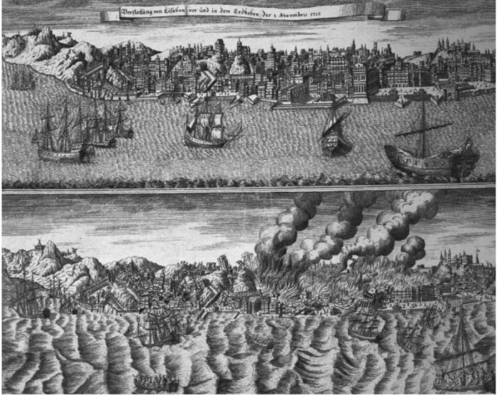
We only give a few examples. Here, as described in the press, the results of an earthquake, which happened in the Atlantic Ocean, not far from the Pyrenean Peninsula on November 1, 1755. Terrible destruction made it in the capital of Portugal Lisbon. Until now, the ruins of the Majestic Building of the Women's Monastery of Carmo, which has not been restored, rises in the center of the city. These ruins resemble Lisbon residents about the tragedy that came to the city on November 1, 1755. Shortly after the earthquake, the sea retreated, and then a wave of 26 meters high to the city fell into the city. Many residents, fleeing from falling wreckage of buildings, left the narrow streets of the city and gathered on a wide embankment. Floating wave washed off at sea 60 thousand people. Lisbon was not completely flooded because it is located on several high hills, but at low-lying seats, the sea flooded the land at a distance of 15 kilometers from the coast.
On August 27, 1883, a powerful eruption of Kratau volcano, located in the pride of the Indonesian archipelago, occurred. The clouds of the ashes rose to the sky, the strongest earthquake, which gave rise to a wave with a height of 30-40 meters. In a few minutes, this wave washed off in the sea. All the villages located on the low shores of the western part of Java and the south of Sumatra, 35 thousand people died. With a speed of 560 kilometers per hour, the tsunami waves rolled through the Indian and Pacific Oceans, reaching the shores of Africa, Australia and America. Even in the Atlantic Ocean, despite its isolation and remoteness in separate places (France, Panama) there was some water lifting.
On June 15, 1896, the tsunami waves were destroyed on the Eastern Coast of the Japanese Island Honshu 10 thousand houses. As a result, 27 thousand inhabitants died.
It is impossible to fight with tsunami. But you can and need to minimize the damage they bring people. Therefore, now in all seismically active areas where there is a threat to the formation of tsunami waves, special warnings have been created, equipped with the necessary equipment hosting from the seismic seismic seismographs located in different places of the coast of sensitive seismographs. The population of such districts is regularly instructed by the rules of behavior in the threat of the appearance of tsunami waves. The tsunami warning services in Japan and in the Hawaiian Islands have repeatedly submitted anxiety signals about the tsunami approximation, which saved not one thousand human lives.
All types of flows and waves are characterized by the fact that they carry colossal energy in themselves - thermal and mechanical. But mankind is not able to use this energy, unless, of course, do not consider attempts to use the energy of tides and sings. Someone from scientists is probably a fan of statistics, it calculated that the power of naval tide exceeds 10,000,000 kilowatt, and all rivers of the globe - 850000,000 kilowatt. The energy of one square kilometer of the storm sea is rated by billions of kilowatt. What does this mean for us? Only the fact that a person cannot use a millionth of the energy of tides and storms. To some extent, people use wind energy to receive electricity and other purposes. But this, as they say, another story.
© Vladimir Kalanov,
"Knowledge is power"
Tsunami is one of the most frightening phenomena of nature. It is a wave formed by the "shaking" of the entire thickness of the water in the ocean. The reasons for the appearance of the tsunami are most often underwater earthquakes.
Sitting to the shore, the tsunami grows into a huge shaft height in tens of meters and fell ashore with millions of tons of water. The greatest tsunami in the world had colossal destruction and led to the death of millions of people.
Krakataau, 1883
This tsunami arose not as a result of an earthquake or landslide. The explosion of Volcanana Krakatau in Indonesia gave rise to a powerful wave, rushing through the entire coast of the Indian Ocean.Residents of fishing settlements within a radius of about 500 km from the volcano almost did not have a chance to survive. The victims were observed even in South Africa, on the opposite of the ocean. In all the dead from the tsunami, 36.5 thousand people are considered.
Kuril Islands, 1952
Tsunami, provoked by an earthquake in 7 points, destroyed the city of North-Kurilsk and several fishing villages. Then the inhabitants did not have the concept of tsunami and after the cessation of the earthquake returned to the dwellings, becoming victims of a 20-meter water shaft. Many were absorbed in the second and third waves, because they did not know that the tsunami is a series of waves. About 2300 people died. The authorities of the Soviet Union decided not to report on the tragedy in the media, so only dozens of years later became known about the catastrophe. 
The city of North-Kurilsk was subsequently transferred to a more elevated place. And the tragedy caused the organization in the USSR to alerts on tsunami and more active scientific research in seismology and oceanology.
Lituya Bay, 1958
The earthquake of magnitude of more than 8 points provoked the gather of a huge landslide with a volume of more than 300 million cubic meters consisting of stones and ice of two glaciers. And the lakes of the lake, whose bank hit the bay was added to them. 
As a result, a giant wave has been formed, which has reached a height of 524 m! She swept around the bay, as a language lodging vegetation and the soil on the slopes of the bay, completely destroyed the braid that separated it from Gilbert bay. This is the highest tsunami in the history of the wave. Lituya's shores were not populated, so only 5 fishermen became victims.
Chile, 1960
On May 22, the consequences of a large Chilean earthquake by force of 9.5 points were the eruption of a volcano and tsunami high 25 m high. Almost 6 thousand people died. 
But the killer wave did not calm down. With the speed of the reactive aircraft, it crossed the Pacific Ocean, having carried out 61 people in Hawaii, and got to the shores of Japan. The victims of the tsunami, which emerged at a distance of more than 10 thousand km, became another 142 people. After that, it was decided to warn about the danger of the tsunami even the most remote sections of the coast, which may be on the path of the deadly wave.
Philippines, 1976
The most powerful earthquake caused a wave, the height of which seems to be not impressive - 4.5 m. Unfortunately, the tsunami collapsed on the lowland coast for more than 400 miles. And the inhabitants were not ready for such a threat. The result is more than 5 thousand dead and about 2.5 thousand missing disadvantia. Almost 100 thousand inhabitants of the Philippines remained silent, and many villages along the coastline were simply completely washed together with the inhabitants. 
Papua New Guinea, 1998
The consequence of the earthquake on July 17 was a gigantic underwater landslide, which caused a 15-meter wave. And so a poor country moved a few hits of the elements, died and missing more than 2500 people. And more than 10 thousand inhabitants lost housing and livelihoods. The tragedy has become an impetus to the study of the role of underwater landslides in the occurrence of tsunami. 
Indian Ocean, 2004
On December 26, 2004, he was inscribed forever in the history of Malaysia, Thailand, Myanmar and other countries on the Indian Ocean coast. On this day, Tsunami claimed the lives of about 280 thousand people, and according to unofficial data - up to 655 thousand. 
The underwater earthquake caused the appearance of waves with a height of 30 m, which collapsed on coastal areas for 15 minutes. A large number of dead is explained by several reasons. This is a high degree of population of the coast, the lowest territory, a large number of tourists on the beaches. But the main reason is the lack of an established tsunami alert system and a weak awareness of people about safety measures.
Japan, 2011
The wave height resulting from a nine ball earthquake reached 40 m. The whole world with horror was watching frames, on which the tsunami was painted with coastal buildings, starry courts, cars ...Causes of Tsunami
Tsunami Distribution is, as a rule, with the areas of strong earthquakes. It is subject to a clear geographic pattern determined by the link of seismic areas with the regions of recent and modern processing processes.
It is known that most earthquakes are dedicated to those belts of the Earth, within which the formation of mining systems continues, in particular young people belonging to the modern geological era. The most chickens of the earthquake in the areas of the close neighborhood of large mountain systems with depressions of the seas and oceans.
In fig. 1 shows the scheme of folded mountain systems and the concentrations of epicenter of earthquakes. This scheme clearly reveals two zones of the globe, most exposed to earthquakes. One of them takes a latitudinal position and includes Apennins, Alps, Carpathians, Caucasus, Kopet-Dag, Tien Shan, Pamir and Himalayas. Within this zone, the tsunami is observed on the coasts of the Mediterranean, Adriatic, Aegean, Black and Caspian seas and the northern part of the Indian Ocean. Another zone is located in the meridional direction and passes along the shores of the Pacific Ocean. The latter as it would be bored with underwater mountain ranges whose vertices rise in the form of islands (Aleutian, Kuril, Japanese Islands and others). The tsunami waves are formed here as a result of breaks between the riding mountain ranges and lowering parallel to the ridges by deep-water depressions separating the chains of the islands from the low-alignment region of the Pacific DNA.
The immediate cause of the waves of the Tsunami is most often taking place in the earthquakes of changes in the terrain of the oceanic bottom, leading to the formation of large discharges, failures, etc.
The scale of such changes can be judged by the following example. With an earthquake in the Adriatic Sea, off the coast of Greece on October 26, 1873, the ruptures of the telegraph cable were noted, laid at the bottom of the sea on the four hundred dollar depth. After the earthquake, one of the ends of the torn cable was detected at a depth of more than 600 m. Consequently, the earthquake caused a sharp lowering of the seabed section to a depth of about 200 meters. A few years later, a cable was gaping, laid along a flat bottom, and his ends Found at a depth, different from the same for several hundred meters. Finally, another year after new jolts, the depth of the sea has increased by 400 m.
Even greater disorders of the bottom of the bottom take place with earthquakes in the Pacific Ocean. Thus, with a submarine earthquake in the Bay of Sagami (Japan), with a sudden lift of the oceanic floor section, about 22.5 cube was supplanted. km of water, which collapsed ashore in the form of a wave tsunami.
In fig. 2a depicts the mechanism of occurrence of tsunami as a result of an earthquake. At the time of a sharp immersion of the section of the ocean and occurrence at the bottom of the sea, the depression is rushed to the center, overwhelms the depression and forms a huge convexity on the surface. With a sharp rise in the section of the ocean, significant mass of water is found. On the surface of the ocean, the waves of the tsunami arise, quickly divergers in all directions. Usually they form a series of 3-9 waves, the distance between the ridges of which is 100-300 km, and the height when the waves approaches the shore reaches 30 m or more.
Another reason for causing tsunami is the eruption of volcanoes, towering over the sea surface in the form of islands or located on the oceanic day (Fig. 2b). The most vivid example in this regard is the formation of tsunami when eruption of Volcanana Krakatau in the probe prioral in August 1883. The eruption was accompanied by a volcanic ash with a height of 30 km. The terrible voice of the volcano was heard simultaneously in Australia and on the nearest Islands of Southeast Asia. On August 27, at 10 am, the explosion destroyed the volcanic island at 10 am. At that moment, the waves of the tsunami, spread over all oceans and devastating many of the islands of the Malay archipelago. In the narrower part of the Stern Strait, the wave height reached 30-35 m. Places of water penetrated into the depths of Indonesia and made terrible destruction. On the island of Seisi, four villages were destroyed. Acher, Melak and Bentam, were destroyed, forests and railways are washed away, and fishing vessels are abandoned to land for a distance of several kilometers from the ocean. The shores of Sumatra and Java have become unrecognizable - everything was covered with mud, ashes, corpses of people and animals. This catastrophe brought the death of 36,000 inhabitants of the archipelago. The tsunami waves spread throughout the Indian Ocean from the shores of India in the north to the Cape of Good Hope in the south. In the Atlantic Ocean, they reached the Panama Isthmus, and in the Pacific Ocean - Alaska and San Francisco.
Cases of tsunami at volcanic eruptions are also known in Japan. Thus, on September 23 and 24, 1952, a strong eruption of the underwater volcano on the Reef Maidzin was a few hundred kilometers from Tokyo. The waves formed at the same time reached the island Khotidze to the northeast of the volcano. During this catastrophe, the Japanese hydrographic vessel "Kaye-Maru-5" died, from which observation was conducted.
The third cause of the occurrence of the tsunami is the fall in the sea of \u200b\u200bhuge fragments of rocks caused by the destruction of rock rocks with soil waters. The height of such waves depends on the mass of the material that has fallen into the sea and from the height of its fall. So, in 1930, on the island of Madeira from a height of 200 m, a block was broken, which was the cause of a single wave with a height of 15 m.
Tsunami off the coast of South America
The Pacific coast within Peru and Chile is subject to frequent earthquakes. The changes occurring in the terrain of the bottom of the coastal part of the Pacific Ocean lead to the formation of large tsunami. The highest heights (27 m) waves of the tsunami reached in the Cagliao area during the earthquake in Lima in 1746.
If usually a decrease in the level of the sea preceding the onset of the tsunami waves to the shore, continues from 5 to 35 minutes, then during the earthquake in the Pisco (Peru), the retreating water of the sea returned only after three hours, and in Santa - even a day.
Often the offensive and retreat of Tsunami waves occur here several times in a row. So, in Ikik (Peru) on May 9, 1877, the first wave fell on the coast after half an hour after the main shock of the earthquake, and then for four o'clock waves fell five more times. During this earthquake, the epicenter of which was located 90 km from the Peruvian coast, waves Tsunami reached the coast of New Zealand and Japan.
On August 13, 1868, on the coast, Peru in Arika in 20 minutes after the beginning of the earthquake, a wave was flooded a few meters high, but soon retreated. With a period of a quarter of an hour, there were several more waves smaller in size. After 12.5 hours, the first wave reached the Hawaiian Islands, and after 19 o'clock the coast of New Zealand, where 25,000 people became its victims. The average speed of the tsunami waves between the arika and Valdivia at a depth of 2,200 m was 145 m / s, between arika and grooming at a depth of 5,200 m - 170-220 m / s, and between Arika and Chatam Islands at a depth of 2700 m - 160 m / s.
The most frequent and strong earthquakes is characterized by the Chilean coast area from Cape Concepcion to Chiloe Island. It is known that since the catastrophe of 1562, the city of Concepcion moved 12 strong earthquakes, and the city of Valdivia for the period from 1575 to 1907 was 7 earthquakes. During the earthquake on January 24, 1939, 1,000 people died in Concepcion and its surroundings and 70,000 people were left without bed.
Destruction made by the waves of the Tsunami of 1960, in the city of Puerto Monte
On May 21, 1960, the new earthquake stirred up the Chilean coast in the area of \u200b\u200bCape Concepcion, and then for 10 days shook the entire southern part of the country for 1500 km. During this time, about a thousand people died and about 350,000 people were left without bed. In the cities of Concepcion, Puerto Monte, Temuco and on Chiloe Island, 65,000 buildings were completely destroyed, and 80,000 is seriously damaged. The strongest was the stronger on May 22, when the maximum amplitude of soil fluctuations in Moscow was 1,500 microns. It is three times the amplitude of the oscillation caused by the Ashgabat earthquake of 1948, the epicenter of which was located six times closer to Moscow.
Catastrophic concussions on May 22 gave rise to the waves of the tsunami, which spread through the Pacific Ocean and beyond its limits at a speed of 650-700 km / h. On the Chilean coast, fishing villages and port facilities were destroyed; Hundreds of people were carried by waves. On the island of Chiloe, the waves destroyed four fifths of all buildings.
Consequences of the Tsunami 1960 g, in the Hawaiian Islands
The giant shaft not only devastated the Pacific coast up to California, but also crossed the Pacific Ocean, hitting Hawaii and the Philippines, the coast of Australia and New Zealand, the Kuril Islands and Kamchatka. In Hawaii, in the city of Hilo, dozens of people died during Tsunami, many residents disappeared and got injured.
Consequences of the Tsunami of 1960 off the coast of Japan
36,000 houses were flooded in the Japanese islands, overturned 900 ships and fish boats. On the island of Okinawa, 180 people died and disappeared, 150 inhabitants died in Mommersi settlement. Never have not yet been noted that the tsunami waves, overcoming such a huge distance, retained their destructive power.
At about 6 am on May 24, the waves of the tsunami, having done the path of 16,000 km, reached the Kuril Islands and the shores of Kamchatka. A wave of five-meter height rushed ashore. However, measures to evacuate the population were taken in a timely manner and there were no human victims. On the island of Paramushir, where the trees had the greatest height, the berths of the local fishing collective farm suffered slightly.
Tsunami off the coast of Japan
Tsunami usually accompany the strongest, catastrophic earthquakes occurring on the Japanese islands on average every seven years. As another reason that causes the formation of the tsunami off the coast of Japan, volcanic eruptions can be called. It is known, for example, that as a result of a volcanic explosion on one of the Japanese islands in 1792, rocks of about 1 cube were thrown into the sea. km. Sea wave with a height of about 9 m, formed as a result of falling in the sea of \u200b\u200beruption products, demolished several coastal villages and brought death more than 15,000 inhabitants.
Special force was distinguished by Tsunami during the 1854 earthquake, which destroyed the largest cities of the country - Tokyo and Kyoto. First, the wave of nine-meter height came to the shore. However, she soon poked out, dried by the coastal at a long distance. Over the next 4-5 hours, five or six large waves collapsed ashore. And after 12.5 hours, the tsunami waves, moving at a speed of more than 600 km / h, reached the coast of North America in the San Francisco.
After this terrible catastrophe in some sections of the coast of the island, Honshu were erected by stone walls to protect the coast of destructive waves. However, despite the precautionary measures taken, during the earthquake on June 15, 1896, Honsu Island again suffered from devastating waves. An hour after the start of the earthquake, six to seven big waves were collapsed from 7 to 34 minutes, the maximum height of one of which was 30 meters. The waves were fully washed off the city of Mintko, destroyed 10,000 buildings and brought 27,000 people. And after 10 years, during the earthquake of 1906, on the east coast of the country, at the occurrence of Tsunami, about 30,000 people died.
During the period of the famous catastrophic earthquake of 1923, entirely destroyed by the Japanese capital, the tsunami waves made devastation on the coast, although they did not achieve particularly large sizes, at least in the Tokyo bay. In the southern regions of the country's consequences, the tsunami were even more significant: several villages in this part of the coast were froze, and the naval base of Japan Japosuk was destroyed by 12 km, south of Yokohama. He strongly suffered from sea waves and the city of Kamakura, located on the shore of the Bay of Sagami.
On March 3, 1933 10 years after the 1923 earthquake in Japan, a new strong earthquake occurred, little inferior to the previous one. Underground shocks embraced the whole eastern part of Honshu Island. The greatest disasters of the population during this earthquake were associated with the onset of waves of the tsunami, smeared 40 minutes after the beginning of the earthquake, all the northeastern coast of Honshu. The wave destroyed the port city of Comience, where 1200 houses were destroyed. A large number of villages on the coast were demolished. Judging by newspaper reports, during this disaster died and disappeared about 3,000 people. In total, more than 4500 houses were destroyed and washed with waves, and more than 6,600 houses were partially damaged. Over 50,000 people remained no bed.
Destruction in the city of Comami after the tsunami in March 1933
Tsunami in the Pacific Coast of Russia
The tsunami also is also susceptible to the shores of Kamchatka and the Kuril Islands. Initial information about catastrophic waves in these places belongs to 1737. The famous domestic traveler - geographer S. P. Krasheninnikov wrote: "... a shaking began and continued on the waves about a quarter of an hour so much that many Kamchadal yurts were collapsed and feces fell. Meanwhile, he was learn, a terrible noise and excitement, and suddenly wounded to the shore of the water in the sazhen embroidery on three, which, no little, standing, ran into Morse and retired from the shores at a notable distance. Then the rest of the Earth was secondary, the water came against the previous one, but when casting so far, she ran away that it was impossible to see the sea. At the same time, at the bottom of the sea in the Strait between the first and second Kuril Islands, rocky mountains appeared, which were never visible before, although the earthquakes and floods took place before.
After a quarter of an hour after all this, the shocks of terrible, with nothing with the power of the earthquake, and then shore a wave with a height of a chip in thirty, which still quickly fled back. Soon the water entered its shores, hesitating through long intervals, sometimes covering the shores, sometimes running into the sea. "
During this earthquake, massive rocks collapsed, the reclining wave threw the stone to the shore of the stone weighing in a few pounds. The earthquake was accompanied by a variety of optical phenomena in the atmosphere. In particular, Abbot Preview, another traveler, who observed this earthquake, wrote that the fiery "meteors", scattered on a large space could be seen on the sea.
S. P. Krasheninnikov noted all the most important features of the tsunami: the earthquake preceding the flood decrease in the ocean level and, finally, the onset of huge devastating waves.
Grand Tsunami on the coasts of Kamchatka and Kuril took place in 1792, 1841, 1843, 1918. A whole series of earthquakes during the winter of 1923 caused repeated occurrences of catastrophic waves. We know the description of the Tsunami on February 4, 1923, when "three waves rushed to the land of the eastern coast of Kamchatka one after another, crushed the coastal ice (digest the thickness in the solarium), were transferred with him through the coast spit, low places poured. The ice on a low location near the seedist turned out to be thrown almost 1 mile 400 seedling from the coast; On the hills, the ice remained on a three-seat height above sea level. In the incomplete points of the Eastern Coast, this unprecedented phenomenon caused some harm and destruction. " The natural disaster covered the extensive coastline with a length of 450 km.
On April 13, 1923, the renewed underground shocks caused a wave tsunami to 11 m tsunami, to the foundation of the collapse of the coastal buildings of fish conservation plants, some of which were cut off with peasic ice.
Strong tsunami was celebrated on the coast of Kamchatka and the Kuril Islands in 1927, 1939 and 1940.
On November 5, 1952, an earthquake that has reached 10 points occurred on the east coast of Kamchatka and the Kuril Islands and accompanied by the exclusive tsunami in their consequences that caused severe destruction in North-Kurilsk. It began at 3 o'clock 57 minutes local time. 4 hours 24 minutes, i.e. 26 minutes after the start of the earthquake, the ocean level quickly fell and places the water retreated from the coast of 500 m. Then, strong waves of Tsunami collapsed to the Kronotsky Peninsula's coast from Sarychev Island. Later, they reached the Kuril Islands, capturing the lane of the shore with a length of about 800 km. The second wave followed the second, even stronger. After her arrival on the island of Paramushir, all buildings were destroyed, located not higher than 10 m above the ocean.
One of the houses in the city of North-Kurilsk, transferred by the wave to the port part of the city during the Tsunami in November 1952
Tsunami in the Hawaiian Islands
The coasts of the Hawaiian Islands are often subject to tsunami. Only for the last attachment, the devastating waves fell on the archipelago 17 times. High force was distinguished by Tsunami in Hawaii in April 1946.
From the area of \u200b\u200bthe epicenter of the earthquake in the area of \u200b\u200bthe island of Uzak (Aleuta Islands), the waves moved at a speed of 749 km / h. The distance between the crests of the waves reached about 150 km of a well-known American oceanologist, the former witness of this natural disaster, F. Shepard celebrated the gradual increase in the height of the waves, who collapsed ashore with an interval of 20 minutes. The references on the timeline successively accounted for 4, 5, 2 and 6, 8 m above the level of the tide.
The damage caused by the sudden onset of the waves was very large. A significant part of the city of Hilo on the island of Hawaii was destroyed. Part of the houses collapsed, others were transferred by water for a distance of more than 30 m. Streets and embankments were cluttered with fragments, overpriced by barricades from inspired cars; There and the ugly cozers of small ships rose to the waves. Bridges and railways were destroyed. On the coastal plain among the grit, the numerous boulders of the corals were scattered among the root of vegetation, the corpses of people and animals were visible. The catastrophe took 150 human lives and caused a loss of 25 million dollars. This time, the waves reached the banks of North and South America, the greatest wave was noted near the epicenter - in the western part of the Aleutian islands. A livehouse of cattle-cap, standing at an altitude of 13.7 m above sea level, and was also demolished by radio.
Boat, thrown ashore, during the tsunami in 1946 in the Hawaiian Islands
application
Fig. 1. Areas of appearance of tsunami in coasts of the seas and oceans (1) and the distribution of the epicenter of the largest earthquakes (2)
Fig. 2. The scheme of the occurrence of the tsunami waves by offsetting the seabed section (A) and under the underwater eruption (b)
Literature:
1. Grandkow A., Koshekin B. Tsunami. - Leningrad: 1964
2. Murtei T. Seismic Sea Waves prices. - Leningrad: 1981
3. Ponivin I. D. Waves prices. - Leningrad: 1965
4. Tsunami problem. Digest of articles. - M.: 1968
5. Solovyov S. L., Guo Ch. N. Catalog of Tsunami on the eastern coast of the Pacific Ocean. - M.: 1975
6. Solovyov S. L., Ch. N. Catalog Tsunami on the west coast of the Pacific Ocean. - M.: 1974
Mareographer - device recording sea level fluctuations
Tsunami is a formidable phenomenon of nature, sampled as a result of eruption of volcanoes or earthquakes in coastal areas. This is a gigantic wave covering the coast for many kilometers inside. The term "tsunami" has a Japanese origin, he sounds like a "big wave in the bay" in the literal translation. It is Japan who most often suffers from the blows of the elements, because it is located in the zone of the Pacific "Fiery Ring" - the largest
Causes of occurrence
Tsunami is formed as a result of "shaking" billions of tons of water. How the circles from the stone abandoned into the water, the waves are running out in different directions at a speed of about 800 km per hour to reach the coast and spill on it with a huge shaft that destroys everything in its path. And often in people who found themselves in the zone of the tsunami, there are few minutes to leave a dangerous place. Therefore, it is very important to warn the inhabitants of the inhabitants on time, without sorry for this funds.
The largest tsunami over the past 10 years

The terrible tragedy occurred in the Indian Ocean in 2004. The underwater earthquake of magnitude 9.1 caused the appearance of giant waves with a height of up to 98 m. After a few minutes, they reached the coast of Indonesia. In total, 14 countries were in the disaster zone, including Sri Lanka, India, Thailand, Bangladesh.
It was the biggest tsunami in the entire history of the number of victims, which reached 230 thousand. Densely populated coastal areas turned out to be not equipped with danger, which caused such quantity
dead. But the victims could be much more if in the oral legends of the individual peoples of these countries, information about the tsunami in antiquity was not preserved. And some families told that they managed to leave a dangerous place thanks to children who learned about gigantic waves in the lessons. And the retreat of the sea, before returning in the form of a fatally dangerous tsunami, served them to run higher on the slope. This confirmed the need to teach people to the rules of conduct in an emergency.
The biggest tsunami in Japan
In the spring of 2011, the trouble hit. The coast of the country had an earthquake of magnitude 9.0, which led to the appearance of waves with a height of up to 33 m. In some reports, other numbers were noted - the ridges of water reached 40-50 m.

Despite the fact that almost all coastal have dams to protect against tsunami, it did not help in the earthquake zone. The number of dead, as well as those worn in the ocean and missing more than 25 thousand people. People across the country with the alarm were honored in the lists of victims from the earthquake and the tsunami, afraid to detect their relatives and relatives in them.
125 thousand buildings were destroyed, transport infrastructure was damaged. But the most dangerous consequence became an accident at a nuclear power plant. She almost led to a nuclear catastrophe in a global scale, especially since radioactive contamination affected the water of the Pacific Ocean. At least Japanese energy, rescuers and self-defense forces were thrown on the elimination of the accident. Leading nuclear powers of the world also sent their specialists to help rescue from ecological catastrophe. And although now the situation at the NPP stabilized, scientists still cannot fully assess its consequences.

Tsunami's alert services notified about the dangers of the Hawaiian Islands, the Philippines and other territories lying in the risk area. But, fortunately, their shores reached highly weakened waves with a height of no more than three meters.
So, the largest tsunami over the past 10 years have happened in the Indian Ocean and in Japan.
Large catastrophes of the decade
Indonesia and Japan are among countries where destroying waves happen quite often. For example, in July 2006, Tsunami was formed in Java again as a result of a devastating underwater shock. Waves that reached 7-8 m, rolled along the coast, capturing even those sites that miraculously were not injured during the deadly tsunami 2004. Residents and guests of the resort regions survived the horror of helplessness before nature. In total, 668 people died during the rampant of the elements, and more than 9 thousand were asked for medical care.

In 2009, the major tsunami happened on the Samoa Archipelago, where almost 15-meter waves went through the islands, destroying everything in their path. The number of victims amounted to 189 people, mostly children who were on the coast. But the operational work of the Tsunami Prevention Center in the Pacific made it possible to avoid even large human losses, allowing you to evacuate people in safe places.
The largest tsunami over the past 10 years has occurred in the quiet and Indian Oceans off the coast of Eurasia. But this does not mean that such catastrophes cannot happen in other areas of the globe.
Destructive tsunami in the history of mankind
Human memory has retained information about gigantic waves observed in antiquity. The oldest references to the tsunami, which happened due to the eruption of the volcano on the island of Big Santorin. This event dates back to 1410 by our era.
It was antiquity. The explosion raised in the sky most of the island, leaving at his place instantly filling the sea water. From a collision with a chipped magma, the water sharply boiled and evaporated, amplifying an earthquake. The Water of the Mediterranean Sea boiled down, forming gigantic waves that have embraced all the coast. The ruthless element took 100 thousand lives, which is a very large number even for modernity, not that for ancient times. According to many scientists, this is precisely this eruption and the tsunami resulting as a result of it led to the disappearance of the critical culture - one of the most mysterious ancient civilizations on Earth.
In 1755, the city of Lisbon was almost completely erased from the face of the Earth by a terrible earthquake, fires arising from his result, and a terrible wave, surging for the city afterwards. 60000 people died, many were injured. Sailors from ships that came to the port of Lisbon after the catastrophe did not recognize the surrounding area. This trouble has become one of the reasons for the loss of portugal of the title of the Great Sea Power.
30 thousand people became victims of the Tsunami of 1707 in Japan. In 1782, disaster in the South China Sea took the lives of 40 thousand people. Krakataau (1883) also caused the occurrence of the tsunami, with which the death of 36.5 thousand people is connected. In 1868, the number of victims of huge waves in Chile amounted to more than 25 thousand. 1896 was marked by the new tsunami in Japan, which took more than 26 thousand lives.
Alaskan Tsunami
An incredible wave was formed in 1958 in the Bay of Lituya in Alaska. The root cause of its occurrence was also an earthquake. But there are also other circumstances. As a result of the earthquake from the slopes of mountains on the coast of the Bay, a giant landslide came up, which made about 300 million cubic meters. m stones and ice. All this collapsed in the water of the bay, causing the formation of a tremendous wave, reaching the height of 524 m! The scientist Miller believes that the largest tsunami in the world happened before that.
At the opposite coast, the blow of such power was collapsed that all vegetation and mass of loose rocks were completely demolished on the slopes, the rock base was exposed. Three ships, which were in the Gulf of Gulf, had a different destiny. One of them sank, the second crashed, but the team managed to escape. And the third ship, being on the crest of the wave, was transferred through the braid that separated the bay, and thrown into the ocean. Only a miracle of the sailors did not die. Then they recalled how during the forced "flight" saw below the vehicles of the tops of the trees grew up on the spit.
Fortunately, the shores of the Bay of Lituya are almost desertless, so such an unparalleled wave caused tangible harm. The largest tsunami cost without great human victims. It is believed that only 2 people died.
Tsunami at the Russian Far East
In our country, the Pacific Coast of Kamchatka and the Kuril Islands includes a tsunamasy zone. They also lie in the seismically unstable area, where the devastating earthquakes often occur, and volcanic eruptions.
The largest tsunami in Russia was recorded in 1952. Waves that reached the heights of 8-10 meters were collapsed into the Kuril Islands and Kamchatka. The population was not prepared for such a turn of events after the earthquake. Those who, after the cessation of underground jog, returned to the surviving houses, for the most part, did not get out of them. The city of North-Kurilsk was almost completely destroyed. The number of victims is estimated at 2336 people, but perhaps they are much more. A few days before the 35th anniversary of the October Revolution, the tragedy was silent for years, only rumors went about her. The city was transferred to a higher and safe place.
The Kuril Tragedy became the basis for organizing a tsunami alert service in the USSR.
Lessons of the past

In the Atlantic Ocean, the coast of Brazil has a strong earthquake of 6.7 points, at a very low depth of only 6 miles, and it is impossible to determine whether it caused tsunami, since all the booms of tsunami warnings in the Atlantic, except one, offline, and cannot communicate Warnings.
The east coast may be threatened if such a wave goes around, but we cannot warn us because the US Department of Commerce could not repaired Bui.
The earthquake occurred at 1:33 am in the morning of the east coast, at a depth of only 6 miles.
According to the Tsunami Warning Center, for the Eastern Coast of the United States "There is no danger of tsunami." I wonder how they can make this assessment, given the fact that our booms of tsunami warning are non-working.
Here is a statement issued by the Tsunami Warnings Center:
WEXX32 PAAQ 300646.
Tibate.
Tsunami Information Statement Number 1
NWS National Tsunami Warning Center Palmer AK
146 am Est Thu Nov 30 2017
... This is a tsunami information state state for the u.s. East Coast
Gulf of Mexico States, And Eastern Canada ...
* Based on the Earthquake Location Near The Mid-Atlantic Ridge,
a Damaging Tsunami Is Not Expected.
* An Earthquake Has Occurred with Parameters Listed Below.
Preliminary Earthquake Parameters.
———————————
* The Following Parameters Are Based on a Rapid Preliminary
assessment And Changes May Occur.
* Magnitude 6.5.
* Origin Time 0133 EST NOV 30 2017
0033 CST NOV 30 2017
0233 AST NOV 30 2017
0633 UTC NOV 30 2017
* Coordinates 1.1 South 23.5 WEST
* Depth 6 Miles
* Location Near the Central Mid-Atlantic Ridge
ADDITIONAL INFORMATION AND NEXT UPDATE
————————————–
* Refer to the Internet Site Tsunami.gov for more information.
* Caribbean Coastal Regions SHOLD REFER TO THE PACIFIC
Tsunami Warning Center Messages AT Tsunami.gov.
* This Will Be The Only U.S. National Tsunami Warning Center
message Issued For This Event Unless Additional Information
becomes Available.
If they are true, we have nothing to worry about. If, they are not right, the tsunami passes through the open ocean at a speed of about 600 miles per hour. First hit on the northern coast of Brazil. If we heard that Brazil suffered over the next two hours, then we will hit us about four hours.
First in North Carolina. A few minutes later, South Delaware and New Jersey will be amazed. Minutes after that, New York and Long Island. At about the same time, when New York hit, the whole southeast will also be attacked.
The National Data Center Buuv (NDBC) is part of the National Oceanic and Atmospheric Studies (NOAA), which is part of the US Department of Commerce.
According to NDBC, the following tsunami warning booms (listed from the south to the north, as the southern buoy will be closest to the earthquake) in the Atlantic, offline:
Publications on the topic
-
 New Year and Christmas in Denmark - Copenhagen New Year's Tours to Denmark
If you wish to see the homeland of Andersen, feel the real magic fairytale environment of the winter holidays, have fun with ...
-
 Night clubs Ayia Napa. Cyprus. Soyo Club Ayia Napa Soyo Club Ayia Napa Photo Report Facebook
Tasks and Reponsibilities: Product Backlog Management and Prioritizing User Storm In Jira and Confluence; Managing Products In The ...